
File:ISS018-E-7727 NASA Asau Savai'i, Samoa.jpg

Size of this preview: 800 × 532 pixels. Other resolutions: 320 × 213 pixels | 640 × 426 pixels | 1,024 × 681 pixels | 1,280 × 851 pixels | 2,560 × 1,703 pixels | 4,312 × 2,868 pixels.
Original file (4,312 × 2,868 pixels, file size: 2.97 MB, MIME type: image/jpeg)
| This is a file from the Wikimedia Commons. Information from its description page there is shown below. Commons is a freely licensed media file repository. You can help. |
Summary
| Description |
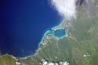
English: Savai'i island, north west coast, reefs, Asau taken by NASA at an altitude of 192 nautical miles (356 km)
Gagana Samoa: Le Itu Asau, Savai'i (le ata mai NASA)
Русский: Район Асау на острове Савайи в Самоа. Фото с сайта НАСА. |
| Date | |
| Source |
<http://eol.jsc.nasa.gov/scripts/sseop/photo.pl?mission=ISS018&roll=E&frame=7727> (). Image Science and Analysis Laboratory, NASA-Johnson Space Center. "The Gateway to Astronaut Photography of Earth." |
| Author |
NASA
|
| Camera location | | View this and other nearby images on: OpenStreetMap |
|---|
This image or video was catalogued by Kennedy Space Center of the United States National Aeronautics and Space Administration (NASA) under Photo ID: ISS018-E-7727. This tag does not indicate the copyright status of the attached work. A normal copyright tag is still required. See Commons:Licensing. Other languages:
|
Licensing
This file is in the public domain in the United States because it was created by the Image Science & Analysis Laboratory, of the NASA Johnson Space Center. NASA copyright policy states that "NASA material is not protected by copyright unless noted". (NASA media use guidelines or Conditions of Use of Astronaut Photographs).
Photo source: ISS018-E-7727.
|
File history
Click on a date/time to view the file as it appeared at that time.
| Date/Time | Thumbnail | Dimensions | User | Comment | |
|---|---|---|---|---|---|
| current | 22:48, 26 May 2013 | | 4,312 × 2,868 (2.97 MB) | Ras67 | new rendered from NASA's raw image file, 180 degree rotated |
| 13:03, 25 January 2010 |  | 640 × 437 (50 KB) | Teinesavaii | {{Information |Description={{en|1=Savai'i island, north west coast, reefs, Asau taken by NASA at an altitude of 192 nautical miles (356 km)}} |Source=<http://eol.jsc.nasa.gov/scripts/sseop/photo.pl?mission=ISS018&roll=E&frame=7727> (). Image Science and A |
File usage
The following pages on the English Wikipedia use this file (pages on other projects are not listed):
Global file usage
The following other wikis use this file:
- Usage on bn.wikipedia.org
- Usage on it.wikipedia.org
- Usage on mrj.wikipedia.org
- Usage on sk.wikipedia.org
- Usage on uk.wikipedia.org
- Usage on ur.wikipedia.org
- Usage on www.wikidata.org