
File:Hochstift Hildesheim - Homann 1730.jpg

Size of this preview: 450 × 600 pixels. Other resolutions: 180 × 240 pixels | 360 × 480 pixels | 576 × 768 pixels | 768 × 1,024 pixels | 2,112 × 2,816 pixels.
Original file (2,112 × 2,816 pixels, file size: 2.39 MB, MIME type: image/jpeg)
| This is a file from the Wikimedia Commons. Information from its description page there is shown below. Commons is a freely licensed media file repository. You can help. |
Summary
| Description |
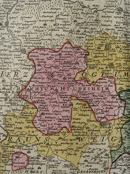
English: Shown in pink, the territory of the Prince-Bishopric of Hildesheim (German: Hochstift Hildesheim) on a map of the Circle of Lower Saxony by Johann Baptist Homann published c. 1730. Hildesheim was bordered by the Kingdom of Hanover (in white) and the Principality of Brunswick-Wolfenbüttel (in yellow), a subdivision of the Duchy of Brunswick. The prince-bishopric included the district of Hundsruck (with the town of Dassel), an exclave located to the southwest (lower left corner on the map). |
| Date | circa 1730 |
| Source | Physical map |
| Author | Johann Baptist Homann |
Licensing
|
This work is in the public domain in its country of origin and other countries and areas where the copyright term is the author's life plus 100 years or fewer. | |
| This file has been identified as being free of known restrictions under copyright law, including all related and neighboring rights. | |
File history
Click on a date/time to view the file as it appeared at that time.
| Date/Time | Thumbnail | Dimensions | User | Comment | |
|---|---|---|---|---|---|
| current | 21:16, 28 May 2019 | | 2,112 × 2,816 (2.39 MB) | Lubiesque | User created page with UploadWizard |
File usage
The following pages on the English Wikipedia use this file (pages on other projects are not listed):
Global file usage
The following other wikis use this file:
- Usage on es.wikipedia.org