
File:Historische Karte CH Helvet.png

Size of this preview: 800 × 510 pixels. Other resolutions: 320 × 204 pixels | 640 × 408 pixels | 1,024 × 653 pixels | 1,280 × 816 pixels | 1,808 × 1,153 pixels.
Original file (1,808 × 1,153 pixels, file size: 514 KB, MIME type: image/png)
| This is a file from the Wikimedia Commons. Information from its description page there is shown below. Commons is a freely licensed media file repository. You can help. |
Summary
| Description |
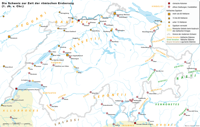
Deutsch: Das Gebiet der heutigen Schweiz zur Zeit der römischen Eroberung im 1. Jahrhundert vor Christus. Keltische (Helvetier, Rauraker), Ligurische (Lepontier u.a.) und Rätische Siedlungen und Fundstätten der La Tène-Zeit |
|
| Date | ||
| Source | own work; archäologische Fundorte: Andres Furger-Gunti: Die Helvetier: Kulturgeschichte eines Keltenvolkes. Neue Zürcher Zeitung, Zürich 1984, S. 178. | |
| Author | Marco Zanoli | |
| Permission (Reusing this file) |
|
File history
Click on a date/time to view the file as it appeared at that time.
| Date/Time | Thumbnail | Dimensions | User | Comment | |
|---|---|---|---|---|---|
| current | 08:18, 10 January 2022 | | 1,808 × 1,153 (514 KB) | Sidonius | Lepontier und andere Stämme südlich der Alpen als Kelten eingefärbt |
| 09:28, 20 May 2020 |  | 2,500 × 1,594 (759 KB) | Sidonius | -Kartenlayout überarbeitet -Fundstätten und Siedlungen der La Tènezeit ergänzt | |
| 04:45, 4 July 2010 |  | 2,089 × 1,332 (277 KB) | DcoetzeeBot | Remove watermark, add author and license data to image metadata, decrease filesize with pngcrush | |
| 07:36, 27 August 2008 |  | 2,089 × 1,332 (439 KB) | Sidonius | nochmals kleinere Korrekturen | |
| 13:57, 14 October 2007 |  | 1,500 × 956 (169 KB) | Sidonius | Lepontier als Kelten markiert, Name von Augusta Raurica verändert in Colonia Raurica | |
| 14:28, 19 January 2007 |  | 1,500 × 956 (167 KB) | Sidonius | ergänzt | |
| 16:10, 6 January 2007 |  | 1,500 × 956 (155 KB) | Sidonius | {{Information |Description={{de|Keltische (Helvetier, Rauraker, Lepontier u.a.) und Rätische Besiedlung der heutigen Schweiz zur Zeit der römischen Eroberung im 1. Jahrhundert vor Chris |
File usage
The following pages on the English Wikipedia use this file (pages on other projects are not listed):
Global file usage
The following other wikis use this file:
- Usage on als.wikipedia.org
- Usage on bg.wikipedia.org
- Usage on br.wikipedia.org
- Usage on ca.wikipedia.org
- Usage on de.wikipedia.org
- Helvetier
- Tiguriner
- Lepontier
- Ur- und Frühgeschichte Mitteleuropas
- Benutzer:Sidonius
- Iuliomagus (Schleitheim)
- Augusteische Alpenfeldzüge
- Seduner
- Tougener
- Benutzer:Ajnem/Geschichte der Stadt und des Kantons Bern
- Römerlager Dangstetten
- Benutzer:GerhardSchuhmacher/Römer am Hochrhein
- Benutzer:GerhardSchuhmacher/Alpen-Limes
- Benutzer:GerhardSchuhmacher/Zwischenablage
- Usage on eo.wikipedia.org
- Usage on fr.wikipedia.org
- Usage on fr.wiktionary.org
- Usage on hu.wikipedia.org
- Usage on id.wikipedia.org
- Usage on it.wikipedia.org
- Usage on la.wikipedia.org
- Usage on nl.wikipedia.org
- Usage on no.wikipedia.org
- Usage on ru.wikipedia.org
- Usage on sl.wikipedia.org