
File:High Street, Bramley opposite the Library - geograph.org.uk - 527410.jpg
No higher resolution available.
High_Street,_Bramley_opposite_the_Library_-_geograph.org.uk_-_527410.jpg (640 × 519 pixels, file size: 127 KB, MIME type: image/jpeg)
| This is a file from the Wikimedia Commons. Information from its description page there is shown below. Commons is a freely licensed media file repository. You can help. |
Summary
| Description |
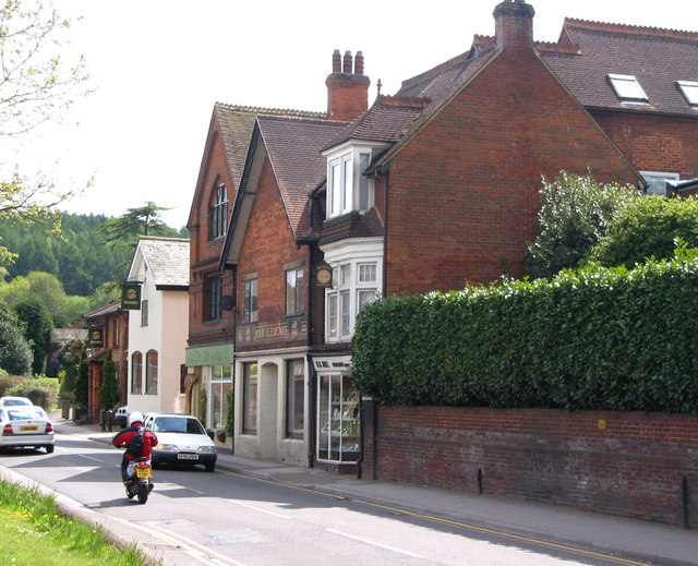
English: High Street, Bramley opposite the Library The tall Victorian building is the site of the Bramley Brewery, owned by the Smith family. Beer was brewed on this site from 1865 by William Smith. In 1901 his son Morton Smith was listed on the census as brewer and jeweller. In 1904 it was bought by Brufords of Cranleigh and in 1917 it was taken over by Cobham United Breweries.
Further down, still visible in the photo, was the Foundry also owned by the Smith family. Charles Smith, William's father bought the foundry in 1847. |
| Date | |
| Source | From geograph.org.uk |
| Author | Clare |
| Attribution (required by the license) | Clare / High Street, Bramley opposite the Library / |
| Camera location | | View this and other nearby images on: OpenStreetMap |
|---|
_heading:180.00&language=en)
| Object location | | View this and other nearby images on: OpenStreetMap |
|---|
_heading:180.00&language=en)
Licensing

|
This image was taken from the Geograph project collection. See this photograph's page on the Geograph website for the photographer's contact details. The copyright on this image is owned by Clare and is licensed for reuse under the Creative Commons Attribution-ShareAlike 2.0 license.
|
This file is licensed under the Creative Commons Attribution-Share Alike 2.0 Generic license.
Attribution: Clare
- You are free:
- to share – to copy, distribute and transmit the work
- to remix – to adapt the work
- Under the following conditions:
- attribution – You must give appropriate credit, provide a link to the license, and indicate if changes were made. You may do so in any reasonable manner, but not in any way that suggests the licensor endorses you or your use.
- share alike – If you remix, transform, or build upon the material, you must distribute your contributions under the same or compatible license as the original.
File history
Click on a date/time to view the file as it appeared at that time.
| Date/Time | Thumbnail | Dimensions | User | Comment | |
|---|---|---|---|---|---|
| current | 16:28, 5 February 2011 | | 640 × 519 (127 KB) | GeographBot | == {{int:filedesc}} == {{Information |description={{en|1=High Street, Bramley opposite the Library The tall Victorian building is the site of the Bramley Brewery, owned by the Smith family. Beer was brewed on this site from 1865 by William Smith. In 1901 |
File usage
The following pages on the English Wikipedia use this file (pages on other projects are not listed):
Global file usage
The following other wikis use this file:
- Usage on azb.wikipedia.org
- Usage on ceb.wikipedia.org
- Usage on cy.wikipedia.org
- Usage on es.wikipedia.org
- Usage on fa.wikipedia.org
- Usage on fr.wikipedia.org
- Usage on id.wikipedia.org
- Usage on lld.wikipedia.org
- Usage on no.wikipedia.org
- Usage on pl.wikipedia.org
- Usage on www.wikidata.org
- Usage on zh-min-nan.wikipedia.org