
File:Hale House - geograph.org.uk - 1524371.jpg
No higher resolution available.
Hale_House_-_geograph.org.uk_-_1524371.jpg (640 × 426 pixels, file size: 207 KB, MIME type: image/jpeg)
| This is a file from the Wikimedia Commons. Information from its description page there is shown below. Commons is a freely licensed media file repository. You can help. |
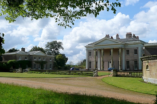
This is a photo of listed building number 1301070. |
Summary
| Description |
English: Hale House Checked carefully with the GPS, I am standing just inside the eastern boundary of the square and the house is wholly within.
The current Hale House was built, to Palladian style in the early to mid 18th century, by Thomas Archer, who worked for Queen Anne and was a well-known architect of his day. |
| Date | |
| Source | From geograph.org.uk |
| Author | Graham Horn |
| Attribution (required by the license) | Graham Horn / Hale House / |
| Camera location | | View this and other nearby images on: OpenStreetMap |
|---|
_heading:202.00&language=en)
| Object location | | View this and other nearby images on: OpenStreetMap |
|---|
_heading:202.00&language=en)
Licensing

|
This image was taken from the Geograph project collection. See this photograph's page on the Geograph website for the photographer's contact details. The copyright on this image is owned by Graham Horn and is licensed for reuse under the Creative Commons Attribution-ShareAlike 2.0 license.
|
This file is licensed under the Creative Commons Attribution-Share Alike 2.0 Generic license.
Attribution: Graham Horn
- You are free:
- to share – to copy, distribute and transmit the work
- to remix – to adapt the work
- Under the following conditions:
- attribution – You must give appropriate credit, provide a link to the license, and indicate if changes were made. You may do so in any reasonable manner, but not in any way that suggests the licensor endorses you or your use.
- share alike – If you remix, transform, or build upon the material, you must distribute your contributions under the same or compatible license as the original.
File history
Click on a date/time to view the file as it appeared at that time.
| Date/Time | Thumbnail | Dimensions | User | Comment | |
|---|---|---|---|---|---|
| current | 03:22, 3 March 2011 | | 640 × 426 (207 KB) | GeographBot | == {{int:filedesc}} == {{Information |description={{en|1=Hale House Checked carefully with the GPS, I am standing just inside the eastern boundary of the square and the house is wholly within. The current Hale House was built, to Palladian style in the e |
File usage
The following pages on the English Wikipedia use this file (pages on other projects are not listed):
Global file usage
The following other wikis use this file:
- Usage on dag.wikipedia.org
- Usage on es.wikipedia.org
- Usage on fr.wikipedia.org
- Usage on it.wikipedia.org
- Usage on nl.wikipedia.org
- Usage on pl.wikipedia.org
- Usage on www.wikidata.org