
File:Gorgon Barrow Island.png
No higher resolution available.
Gorgon_Barrow_Island.png (558 × 447 pixels, file size: 194 KB, MIME type: image/png)
| This is a file from the Wikimedia Commons. Information from its description page there is shown below. Commons is a freely licensed media file repository. You can help. |
Summary
| Description |
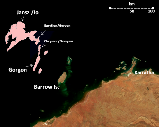
English: Location map showing the approximate location of some of the Greater Gorgon gas fields in realation to Barrow Island and the Western Australian coastline. |
| Date | |
| Source | Own work by uploader; base satellite image is a NASA image downloaded from http://library01.gsfc.nasa.gov/nix/nixImages/screenimage/GL-2002-002149.jpg then cropped and enlarged by me, and in compliance with NASA's policy regarding the use of its images (NASA still images such as this one are not copyrighted and may be used for the rendition of 3-dimensional models for educational or informational purposes, computer graphical simulations, and Internet Web pages (see http://www.nasa.gov/audience/formedia/features/MP_Photo_Guidelines.html). |
| Author | Glen Dillon |
Gas field locations are approximations only based on visual inspection of page 13 of http://www.gorgon.com.au/review/FromClient/Gorgon_Revised_Proposal_PER_Final_Main_Report_20080909.pdf
Licensing
I, the copyright holder of this work, hereby publish it under the following license:
This file is licensed under the Creative Commons Attribution-Share Alike 3.0 Unported license.
- You are free:
- to share – to copy, distribute and transmit the work
- to remix – to adapt the work
- Under the following conditions:
- attribution – You must give appropriate credit, provide a link to the license, and indicate if changes were made. You may do so in any reasonable manner, but not in any way that suggests the licensor endorses you or your use.
- share alike – If you remix, transform, or build upon the material, you must distribute your contributions under the same or compatible license as the original.
File history
Click on a date/time to view the file as it appeared at that time.
| Date/Time | Thumbnail | Dimensions | User | Comment | |
|---|---|---|---|---|---|
| current | 04:03, 20 August 2009 | | 558 × 447 (194 KB) | Glen Dillon | {{Information |Description={{en|1=Location map showing the approximate location of some of the Greater Gorgon gas fields in realation to Barrow Island and the Western Australian coastline.}} |Source=Own work by uploader; base satellite image is a NASA ima |
File usage
The following pages on the English Wikipedia use this file (pages on other projects are not listed):
Global file usage
The following other wikis use this file:
- Usage on de.wikipedia.org
- Usage on nl.wikipedia.org
- Usage on ru.wikipedia.org
- Usage on ta.wikinews.org
- Usage on www.wikidata.org