
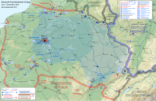
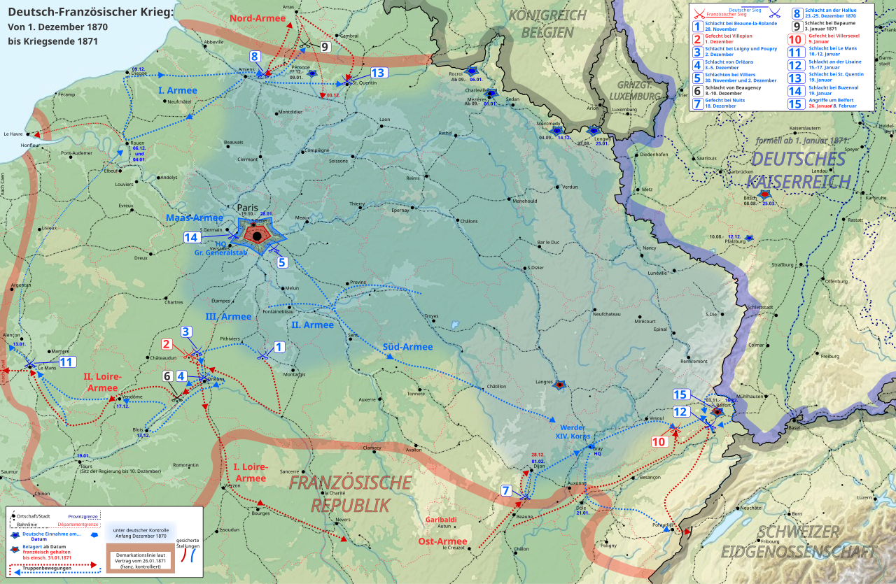
File:Franco-Prussian-War Phase 3 deu ger all.svg

Size of this PNG preview of this SVG file: 800 × 522 pixels. Other resolutions: 320 × 209 pixels | 640 × 417 pixels | 1,024 × 668 pixels | 1,280 × 835 pixels | 2,560 × 1,670 pixels | 1,041 × 679 pixels.
Original file (SVG file, nominally 1,041 × 679 pixels, file size: 3.14 MB)
| This is a file from the Wikimedia Commons. Information from its description page there is shown below. Commons is a freely licensed media file repository. You can help. |
Summary
| Description |
Deutsch: Karte des Deutsch-Französischen-Kriegs, Verlauf von Anfang Dezember 1870 bis Kriegsende 1871
Abgeleitet aus File:France_map_Lambert-93_topographic_with_regions_and_departements-blank.svg |
| Date | |
| Source | Own work |
| Author | Enyavar |
Licensing
I, the copyright holder of this work, hereby publish it under the following license:
This file is licensed under the Creative Commons Attribution-Share Alike 4.0 International license.
- You are free:
- to share – to copy, distribute and transmit the work
- to remix – to adapt the work
- Under the following conditions:
- attribution – You must give appropriate credit, provide a link to the license, and indicate if changes were made. You may do so in any reasonable manner, but not in any way that suggests the licensor endorses you or your use.
- share alike – If you remix, transform, or build upon the material, you must distribute your contributions under the same or compatible license as the original.
File history
Click on a date/time to view the file as it appeared at that time.
| Date/Time | Thumbnail | Dimensions | User | Comment | |
|---|---|---|---|---|---|
| current | 10:47, 30 January 2021 | | 1,041 × 679 (3.14 MB) | Enyavar | details |
| 05:53, 23 January 2021 |  | 1,041 × 679 (3.14 MB) | Enyavar | Phase II, part 2, corrections and first final version | |
| 09:01, 18 January 2021 |  | 1,041 × 679 (3.1 MB) | Enyavar | =={{int:filedesc}}== {{Information |description={{de|1=Karte des Deutsch-Französischen-Kriegs, Verlauf von Anfang Dezember 1870 bis Kriegsende 1871 Warnung: Datei bitte noch nicht in Artikel einbinden, wird noch weiter bearbeitet. Abgeleitet aus File:France_map_Lambert-93_topographic_with_regions_and_departements-blank.svg}} |date=2021-01-18 |source={{own}} |author=Enyavar |permission= |other versions= }} =={{int:license-header}}== {{self|cc-by-sa-4.0}} [[Category:Maps... |
File usage
The following pages on the English Wikipedia use this file (pages on other projects are not listed):
Global file usage
The following other wikis use this file:
- Usage on de.wikipedia.org
- Usage on hsb.wikipedia.org
- Usage on lt.wikipedia.org
- Usage on zh.wikipedia.org