
File:FortCarlos2diagram.jpg

Size of this preview: 600 × 600 pixels. Other resolutions: 240 × 240 pixels | 480 × 480 pixels | 750 × 750 pixels.
Original file (750 × 750 pixels, file size: 61 KB, MIME type: image/jpeg)
| This is a file from the Wikimedia Commons. Information from its description page there is shown below. Commons is a freely licensed media file repository. You can help. |
Summary
| Description |
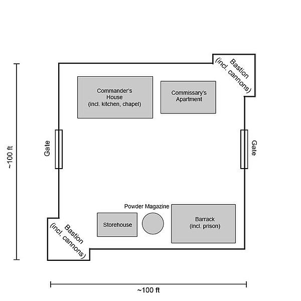
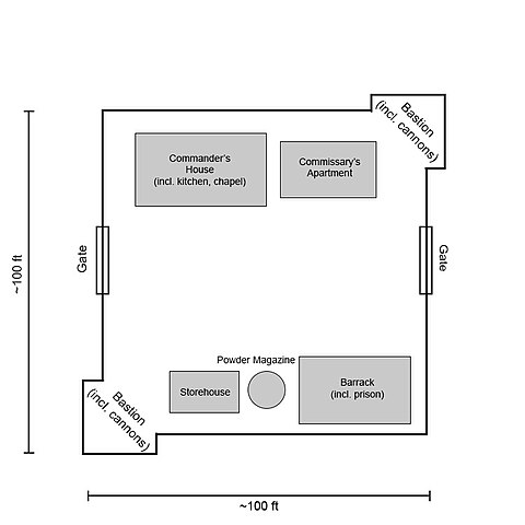
English: Diagram of 1760s era Fort Carlos, Louisiana (present-day Arkansas). Drawn using details from chrome-extension://efaidnbmnnnibpcajpcglclefindmkaj/http://npshistory.com/publications/arpo/colbert-raid.pdf. |
|||
| Date |
|
|||
| Source | Own work | |||
| Author | Samuel Peoples | |||
| Permission (Reusing this file) |
I, the copyright holder of this work, hereby publish it under the following license:
|
File history
Click on a date/time to view the file as it appeared at that time.
| Date/Time | Thumbnail | Dimensions | User | Comment | |
|---|---|---|---|---|---|
| current | 18:19, 7 June 2013 | | 750 × 750 (61 KB) | Samuel Peoples | Improved accuracy. Meant for use as a representation of the general layout/consistence of the Spanish forts at Arkansas Post. |
| 15:23, 5 June 2013 |  | 500 × 500 (41 KB) | Samuel Peoples | User created page with UploadWizard |
File usage
The following pages on the English Wikipedia use this file (pages on other projects are not listed):