
File:First Eblaite Empire.png

Size of this preview: 800 × 508 pixels. Other resolutions: 320 × 203 pixels | 640 × 407 pixels | 1,024 × 650 pixels | 1,324 × 841 pixels.
Original file (1,324 × 841 pixels, file size: 1.29 MB, MIME type: image/png)
| This is a file from the Wikimedia Commons. Information from its description page there is shown below. Commons is a freely licensed media file repository. You can help. |
Summary
| Description |
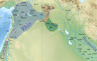
English: Ebla' first kingdom at its height c. 2340 BC.
The first Eblaite kingdom extended from Urshu in the north,1 to Damascus area in the south.2 And from Phoenicia and the coastal mountains in the west,3 4 to Tuttul,5 and Haddu in the east.6 The eastern kingdom of Nagar controlled most of the Khabur basin from the river junction with the Euphrates to the northwestern part at Nabada.7 Page 101 |
| Date | |
| Source | File:Near_East_topographic_map-blank.svg |
| Author | Sémhur |
| This is a retouched picture, which means that it has been digitally altered from its original version. Modifications: First Eblaite Empire. The original can be viewed here: Near East topographic map-blank.svg:
|
Licensing
This file is licensed under the Creative Commons Attribution-Share Alike 4.0 International license.
- You are free:
- to share – to copy, distribute and transmit the work
- to remix – to adapt the work
- Under the following conditions:
- attribution – You must give appropriate credit, provide a link to the license, and indicate if changes were made. You may do so in any reasonable manner, but not in any way that suggests the licensor endorses you or your use.
- share alike – If you remix, transform, or build upon the material, you must distribute your contributions under the same or compatible license as the original.
Original upload log
This image is a derivative work of the following images:
- File:Near_East_topographic_map-blank.svg licensed with Cc-by-sa-3.0,2.5,2.0,1.0, GFDL
- 2009-08-18T18:31:37Z Sémhur 2425x1581 (2442670 Bytes) 3 - New try
- 2009-08-17T15:39:22Z Sémhur 2425x1581 (1815374 Bytes) 2 - With the background...
- 2009-08-17T15:37:36Z Sémhur 2425x1581 (2836 Bytes) {{Information |Description={{en|1=Blank physical map of the [[:en:Near East|Near East]]}} {{fr|1=Carte physique vierge du [[:fr:Proche-Orient|Proche-Orient]].}} |Source={{own}} |Author=[[User:Sémhur|Sémhur]] |Date=2008-08-1
File history
Click on a date/time to view the file as it appeared at that time.
| Date/Time | Thumbnail | Dimensions | User | Comment | |
|---|---|---|---|---|---|
| current | 07:20, 13 June 2015 | | 1,324 × 841 (1.29 MB) | Attar-Aram syria | borders |
| 21:38, 12 June 2015 |  | 1,324 × 841 (1.3 MB) | Attar-Aram syria | color | |
| 02:29, 16 March 2015 |  | 1,324 × 844 (1.29 MB) | Attar-Aram syria | tell hazna | |
| 18:00, 8 March 2015 |  | 1,324 × 844 (1.1 MB) | Attar-Aram syria | added nagar | |
| 18:19, 26 February 2015 |  | 1,326 × 926 (1.38 MB) | Attar-Aram syria | Haddu | |
| 05:36, 23 December 2014 |  | 1,326 × 926 (1.38 MB) | Attar-Aram syria | fixed locations | |
| 02:38, 23 December 2014 |  | 1,326 × 926 (1.38 MB) | Attar-Aram syria | borders | |
| 02:31, 23 December 2014 |  | 1,326 × 926 (1.38 MB) | Attar-Aram syria | User created page with UploadWizard |
File usage
The following pages on the English Wikipedia use this file (pages on other projects are not listed):
- Early Dynastic Period (Mesopotamia)
- Ebla
- History of the ancient Levant
- Igrish-Halam
- Irkab-Damu
- Middle Eastern empires
- Tell Brak
- User:Jacksonmcdonald3425/sandbox
- User:Kazkaskazkasako/Books/History
- User:SomeGuyWhoRandomlyEdits/Early Dynastic IIIa
- User:SomeGuyWhoRandomlyEdits/History of Sumer
- User:SomeGuyWhoRandomlyEdits/List of conflicts in the Near East
- User:배우는사람/Test
Global file usage
The following other wikis use this file:
- Usage on am.wikipedia.org
- Usage on ba.wikipedia.org
- Usage on da.wikipedia.org
- Usage on fa.wikipedia.org
- Usage on fi.wikipedia.org
- Usage on fr.wikipedia.org
- Usage on he.wikipedia.org
- Usage on id.wikipedia.org
- Usage on it.wikipedia.org
- Usage on lt.wikipedia.org
- Usage on nl.wikipedia.org
- Usage on pt.wikipedia.org
- Usage on ru.wikipedia.org
- Usage on sl.wikipedia.org
View more global usage of this file.