
File:Fife Ness Lighthouse - geograph.org.uk - 937536.jpg
No higher resolution available.
Fife_Ness_Lighthouse_-_geograph.org.uk_-_937536.jpg (640 × 427 pixels, file size: 248 KB, MIME type: image/jpeg)
| This is a file from the Wikimedia Commons. Information from its description page there is shown below. Commons is a freely licensed media file repository. You can help. |
Summary
| Description |
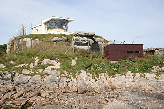
English: Fife Ness Lighthouse. Located at the easternmost point of Fife, marking the north side of the entrance to the Firth of Forth. An example of a low-rise lighthouse. The dark hut below and to the right is a birdwatching hide. Large numbers of birds pass close by just offshore on migration every spring and autumn. |
| Date | |
| Source | From this image at geograph.org.uk; transferred by User:JotaCartas using geograph_org2commons. |
| Author | Anne Burgess |
| Permission (Reusing this file) |
Creative Commons Attribution Share-alike license 2.0 |
| Attribution (required by the license) | Anne Burgess / Fife Ness Lighthouse / |
| Camera location | | View this and other nearby images on: OpenStreetMap |
|---|
| Object location | | View this and other nearby images on: OpenStreetMap |
|---|
_region:GB-GBN_heading:337.00&language=en)
Licensing

|
This image was taken from the Geograph project collection. See this photograph's page on the Geograph website for the photographer's contact details. The copyright on this image is owned by Anne Burgess and is licensed for reuse under the Creative Commons Attribution-ShareAlike 2.0 license.
|
This file is licensed under the Creative Commons Attribution-Share Alike 2.0 Generic license.
Attribution: Anne Burgess
- You are free:
- to share – to copy, distribute and transmit the work
- to remix – to adapt the work
- Under the following conditions:
- attribution – You must give appropriate credit, provide a link to the license, and indicate if changes were made. You may do so in any reasonable manner, but not in any way that suggests the licensor endorses you or your use.
- share alike – If you remix, transform, or build upon the material, you must distribute your contributions under the same or compatible license as the original.
File history
Click on a date/time to view the file as it appeared at that time.
| Date/Time | Thumbnail | Dimensions | User | Comment | |
|---|---|---|---|---|---|
| current | 19:29, 4 March 2010 | | 640 × 427 (248 KB) | File Upload Bot (Magnus Manske) | == {{int:filedesc}} == {{Information |Description={{en|1=Fife Ness Lighthouse}} |Source=From [http://www.geograph.org.uk/photo/937536 this image] at [http://geograph.org.uk geograph.org.uk]; transferred by User:JotaCartas using [http://toolserver.org/ |
File usage
The following pages on the English Wikipedia use this file (pages on other projects are not listed):
Global file usage
The following other wikis use this file:
- Usage on ceb.wikipedia.org
- Usage on cs.wikipedia.org
- Usage on de.wikipedia.org
- Usage on fr.wikipedia.org
- Usage on ga.wikipedia.org
- Usage on www.wikidata.org