
File:Faults in Moenkopi Formation Moab Canyon Utah USA 01.jpg

Size of this preview: 800 × 532 pixels. Other resolutions: 320 × 213 pixels | 640 × 426 pixels | 1,024 × 681 pixels | 1,280 × 851 pixels | 3,008 × 2,000 pixels.
Original file (3,008 × 2,000 pixels, file size: 3.63 MB, MIME type: image/jpeg)
| This is a file from the Wikimedia Commons. Information from its description page there is shown below. Commons is a freely licensed media file repository. You can help. |
Summary
| Description |
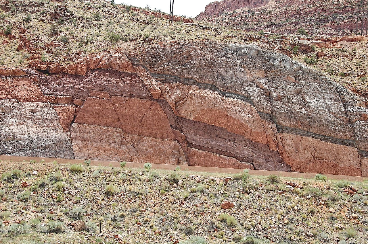
English: This image shows one of the only outcrops of the Pennsylvanian Period Honaker Trail Formation that may be viewed in the vicinity of Moab. In this setting the Honaker Trail Formation serves as the base of a strata graphic sequence which form the cliffs that occur on the west side of the Moab valley. This outcrop occurs across highway 191, immediately opposite and directly south of, the visitor center parking lot at Arches National Park. The Honaker Trail Formation underlies the visible strata throughout the area, but is buried and impossible to view elsewhere in the near vicinity of Moab. The fault and the road cut for highway 191 provide a rare circumstance where visitors to Moab, Arches National Park, and Canyonlands National Park may see this approximately 300 miilion year old Pennsylvanian Period layer of rock.
sources: 1) http://www.gly.uga.edu/railsback/VFT/VFTMoabFault.html 2) http://geology.byu.edu/home/sites/default/files/geo-stud-volume-19-part-2-melton1.pdf |
| Date | |
| Source | https://www.flickr.com/photos/jsjgeology/8471260787/in/set-72157632763455730 |
| Author | James St. John (jsj1771) https://www.flickr.com/people/jsjgeology/ |
| Object location | | View this and other nearby images on: OpenStreetMap |
|---|
Licensing
| This image was originally posted to Flickr by jsj1771 at https://www.flickr.com/photos/47445767@N05/8471260787. It was reviewed on 14 December 2013 by FlickreviewR and was confirmed to be licensed under the terms of the cc-by-2.0. |
This file is licensed under the Creative Commons Attribution 2.0 Generic license.
- You are free:
- to share – to copy, distribute and transmit the work
- to remix – to adapt the work
- Under the following conditions:
- attribution – You must give appropriate credit, provide a link to the license, and indicate if changes were made. You may do so in any reasonable manner, but not in any way that suggests the licensor endorses you or your use.
File history
Click on a date/time to view the file as it appeared at that time.
| Date/Time | Thumbnail | Dimensions | User | Comment | |
|---|---|---|---|---|---|
| current | 17:58, 14 December 2013 | | 3,008 × 2,000 (3.63 MB) | GeoWriter | User created page with UploadWizard |
File usage
The following pages on the English Wikipedia use this file (pages on other projects are not listed):
Global file usage
The following other wikis use this file:
- Usage on fr.wikipedia.org
- Usage on he.wikipedia.org
- Usage on ky.wikipedia.org
- Usage on sk.wikipedia.org
- Usage on www.wikidata.org