
File:Elstree and Borehamwood parish UK location map.svg

Size of this PNG preview of this SVG file: 398 × 400 pixels. Other resolutions: 239 × 240 pixels | 478 × 480 pixels | 764 × 768 pixels | 1,019 × 1,024 pixels | 2,038 × 2,048 pixels.
Original file (SVG file, nominally 398 × 400 pixels, file size: 1.73 MB)
| This is a file from the Wikimedia Commons. Information from its description page there is shown below. Commons is a freely licensed media file repository. You can help. |
Summary
| Description |
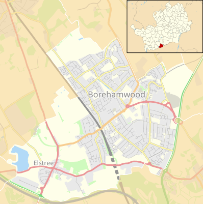
English: Location map of the civil parish of Elstree and Borehamwood, Hertfordshire, England, in 2022, showing roads, railways, rivers and built-up areas. Inset highlights Elstree and Borehamwood among all the civil parishes of Hertfordshire.
Equirectangular map projection on WGS 84 datum, with N/S stretched 160%.
Other road
Railway
Woodland
Built-up area |
| Date | |
| Source |
This file was derived from: |
| Author |
|
.svg)
Licensing
| This work contains information from OpenStreetMap, which is made available under the Open Database License (ODbL).
The ODbL does not require any particular license for maps produced from ODbL data. Prior to 1 August 2020, map tiles produced by the OpenStreetMap Foundation were licensed under the CC-BY-SA-2.0 license. Maps produced by other people may be subject to other licences. |
This file is licensed under the Creative Commons Attribution-Share Alike 4.0 International license.
Attribution: © OpenStreetMap contributors, Nilfanion and Dr Greg. Contains Ordnance Survey data © Crown copyright and database right 2022.
- You are free:
- to share – to copy, distribute and transmit the work
- to remix – to adapt the work
- Under the following conditions:
- attribution – You must give appropriate credit, provide a link to the license, and indicate if changes were made. You may do so in any reasonable manner, but not in any way that suggests the licensor endorses you or your use.
- share alike – If you remix, transform, or build upon the material, you must distribute your contributions under the same or compatible license as the original.
File history
Click on a date/time to view the file as it appeared at that time.
| Date/Time | Thumbnail | Dimensions | User | Comment | |
|---|---|---|---|---|---|
| current | 21:38, 16 February 2022 | | 398 × 400 (1.73 MB) | Dr Greg | Uploaded a work by * Bushey unparished area UK locator map.svg: Nilfanion, created using Ordnance Survey data * Hertfordshire UK parish map (blank).svg: Nilfanion, created using Ordnance Survey data * OpenStreetMap: [http://www.openstreetmap.org/copyright OpenStreetMap contributors] * derivative work: Dr Greg from {{Derived from | Bushey unparished area UK locator map.svg | Hertfordshire UK parish map (blank).svg | display=50 }} * https:/... |
File usage
The following pages on the English Wikipedia use this file (pages on other projects are not listed):
Global file usage
The following other wikis use this file:
- Usage on si.wikipedia.org
- Usage on uz.wikipedia.org