
File:Elevation profiles of Pittsburgh inclines.svg

Size of this PNG preview of this SVG file: 800 × 170 pixels. Other resolutions: 320 × 68 pixels | 640 × 136 pixels | 1,024 × 218 pixels | 1,280 × 272 pixels | 2,560 × 544 pixels | 2,800 × 595 pixels.
Original file (SVG file, nominally 2,800 × 595 pixels, file size: 8 KB)
| This is a file from the Wikimedia Commons. Information from its description page there is shown below. Commons is a freely licensed media file repository. You can help. |
Summary
| Description |
English: Dimensional comparison of 14 passenger inclines (extant and historical) of Pittsburgh, Pennsylvania. |
| Date | |
| Source | Own work |
| Author | Phlegmatic |
| SVG development | This vector image was created with a text editor. |
Source data
| Height | Length | Horiz. length | Grade or angle | Source(s) | |
|---|---|---|---|---|---|
| Castle Shannon | 451 | 1375 | [1] | ||
| Castle Shannon 2 | 2112 | (Variable) | [1][2] | ||
| Clifton | 160 (est.) | 275 (est.) | [3][2] | ||
| Duquesne | 400 | 794 | [4] | ||
| Ft. Pitt | 135 | 350 | [1] | ||
| Knoxville | 375 | 2640 | [1] | ||
| Monongahela | 375 | 640 | [1] | ||
| Mt. Oliver | 377 | 1600 | 20% (lower 400 ft); 25% (rest) | [1] | |
| Norwood | 125 (est.) | 640 (est.) | [3][5] | ||
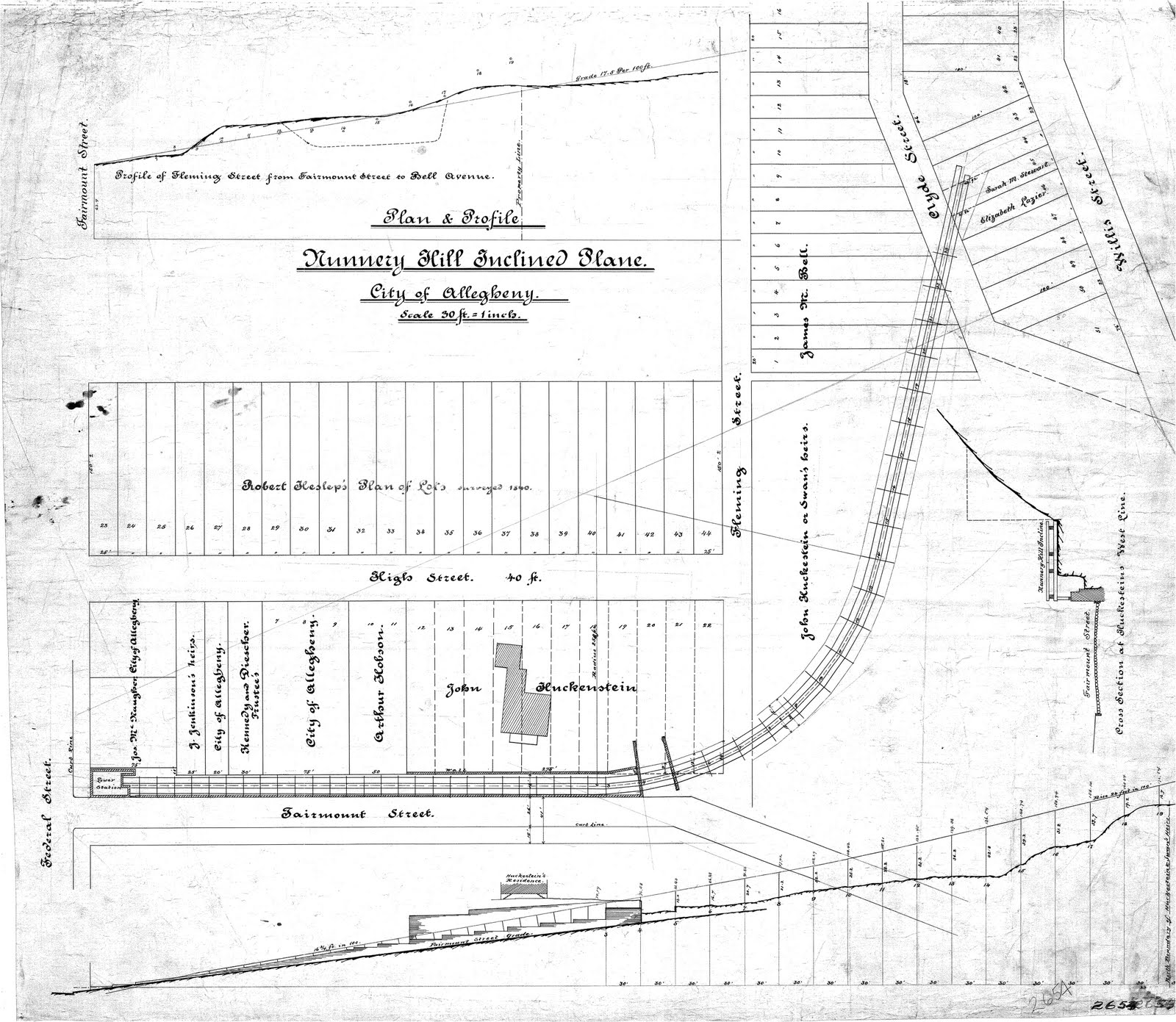
| Nunnery Hill | 220 (est.) | 1100 (est.) | 16.75% (below curve); 24% (above curve) | [6][3][2] | |
| Penn | 330 | 840 | [1] | ||
| Ridgewood | 278 | 32° 31' | [7] | ||
| St. Clair | 361 | 2060 | 14% bottom; 29% top (parabolic arc profile) | [1][8] | |
| Troy Hill | 160 | 370 | [9] |
Sources
- ↑ a b c d e f g h (October 1891). "The Inclined Planes". The Street Railway Journal Souvenir: 37–40.
- ↑ a b c City of Pittsburgh Geodetic and Topographic Survey Maps, 1923-1961. Historic Pittsburgh.
- ↑ a b c G.M. Hopkins Company Maps. Historic Pittsburgh.
- ↑ About the Incline. Duquesne Incline. Retrieved on 18 December 2016.
- ↑ Google Earth elevation data.
- ↑ Plan & Profile: Nunnery Hill Inclined Plane. Retrieved on 18 December 2016. Sometimes-cited height of 300 ft is inaccurate.
- ↑ (31 December 1886). "A Passenger Incline Railroad". Railroad Gazette 18 (53): 912.
- ↑ (28 September 1904). "Incline Cars Make Mad Dash". The Pittsburgh Gazette: 1. (Values for top and bottom grades are evidently transposed; they match map data if switched.)
- ↑ Diescher, Samuel (June 1897). "American Inclined Plane Railways". Cassier's Magazine 12 (2): 89.
Licensing
I, the copyright holder of this work, hereby publish it under the following license:
| This file is made available under the Creative Commons CC0 1.0 Universal Public Domain Dedication. | |
| The person who associated a work with this deed has dedicated the work to the public domain by waiving all of their rights to the work worldwide under copyright law, including all related and neighboring rights, to the extent allowed by law. You can copy, modify, distribute and perform the work, even for commercial purposes, all without asking permission.
|
File history
Click on a date/time to view the file as it appeared at that time.
| Date/Time | Thumbnail | Dimensions | User | Comment | |
|---|---|---|---|---|---|
| current | 21:46, 4 March 2017 | 2,800 × 595 (8 KB) | Phlegmatic | User created page with UploadWizard |
File usage
The following pages on the English Wikipedia use this file (pages on other projects are not listed):