
File:El'ad 2020 street map overlaid on Survey of Palestine map from 1941 (cropped).png
No higher resolution available.
El'ad_2020_street_map_overlaid_on_Survey_of_Palestine_map_from_1941_(cropped).png (677 × 492 pixels, file size: 628 KB, MIME type: image/png)
| This is a file from the Wikimedia Commons. Information from its description page there is shown below. Commons is a freely licensed media file repository. You can help. |
Summary
| Description |
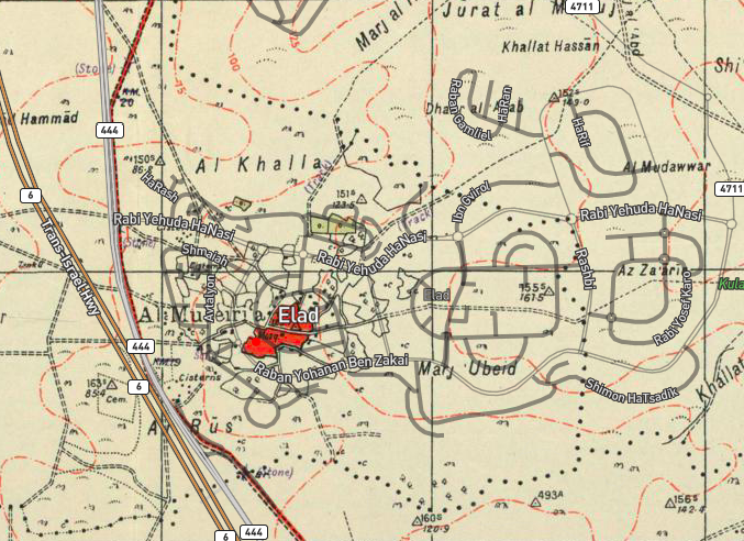
English: Survey of Palestine map: File:14-16-MajdalYaba-1941.jpg |
| Date | and 1942 |
| Source | Data from OpenStreetMap overlaid up a map from Survey of Palestine |
| Author | Data from OpenStreetMap overlaid up a map from Survey of Palestine |
| Other versions |

.png)
Licensing
| This work contains information from OpenStreetMap, which is made available under the Open Database License (ODbL).
The ODbL does not require any particular license for maps produced from ODbL data. Prior to 1 August 2020, map tiles produced by the OpenStreetMap Foundation were licensed under the CC-BY-SA-2.0 license. Maps produced by other people may be subject to other licences. |
This work created by the United Kingdom Government is in the public domain.
This is because it is one of the following:
HMSO has declared that the expiry of Crown Copyrights applies worldwide (ref: HMSO Email Reply)
|
 |
This work was created or ordered by the State of Israel, and is in the public domain because it satisfies one of the conditions stipulated in Israel's copyright statute from 2007 (translation) regarding the State's copyrights:
|

|
File history
Click on a date/time to view the file as it appeared at that time.
| Date/Time | Thumbnail | Dimensions | User | Comment | |
|---|---|---|---|---|---|
| current | 09:00, 23 June 2020 | | 677 × 492 (628 KB) | Onceinawhile | File:El'ad 2020 street map overlaid on Survey of Palestine map from 1941.png cropped 7 % horizontally, < 1 % vertically using CropTool with precise mode. |
File usage
The following pages on the English Wikipedia use this file (pages on other projects are not listed):
Global file usage
The following other wikis use this file:
- Usage on mk.wikipedia.org
.png)