
File:Dovecliffe-railway-station-by-Jonathan-Clitheroe.jpg
No higher resolution available.
Dovecliffe-railway-station-by-Jonathan-Clitheroe.jpg (640 × 443 pixels, file size: 112 KB, MIME type: image/jpeg)
| This is a file from the Wikimedia Commons. Information from its description page there is shown below. Commons is a freely licensed media file repository. You can help. |
Summary
| Description |
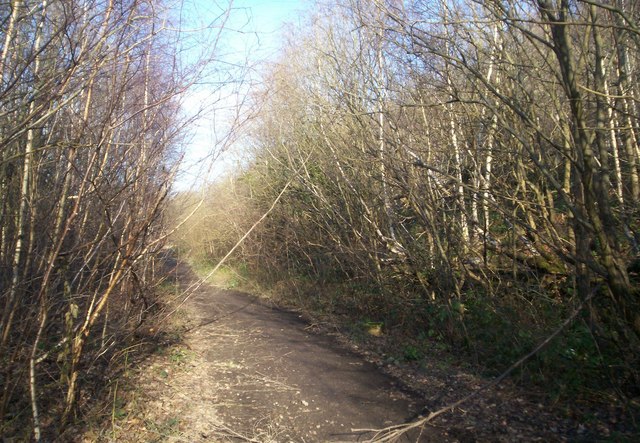
English: Dismantled Railway Line and Platform This track was originally part of the Blackburn Valley railway line which ran between High Royds and Wombwell. Poking through the undergrowth on the right are the remnants of Dovecliffe Station platform. The station closed in the 1950s but the line continued to operate until the 80s, serving Wombwell Main Colliery. |
| Date | |
| Source | From geograph.org.uk |
| Author | Jonathan Clitheroe |
| Permission (Reusing this file) |
Creative Commons Attribution Share-alike license 2.0 |
| Attribution (required by the license) | Jonathan Clitheroe / Dismantled Railway Line and Platform / |
| Camera location | | View this and other nearby images on: OpenStreetMap |
|---|
Licensing

|
This image was taken from the Geograph project collection. See this photograph's page on the Geograph website for the photographer's contact details. The copyright on this image is owned by Jonathan Clitheroe and is licensed for reuse under the Creative Commons Attribution-ShareAlike 2.0 license.
|
This file is licensed under the Creative Commons Attribution-Share Alike 2.0 Generic license.
Attribution: Jonathan Clitheroe
- You are free:
- to share – to copy, distribute and transmit the work
- to remix – to adapt the work
- Under the following conditions:
- attribution – You must give appropriate credit, provide a link to the license, and indicate if changes were made. You may do so in any reasonable manner, but not in any way that suggests the licensor endorses you or your use.
- share alike – If you remix, transform, or build upon the material, you must distribute your contributions under the same or compatible license as the original.
File history
Click on a date/time to view the file as it appeared at that time.
| Date/Time | Thumbnail | Dimensions | User | Comment | |
|---|---|---|---|---|---|
| current | 20:59, 6 June 2009 | | 640 × 443 (112 KB) | Scillystuff | == Summary == {{Information |Description=Dismantled Railway Line and Platform |Source=From [http://www.geograph.org.uk/photo/1192385 geograph.org.uk] |Date=2009-03-06 |Author=[http://www.geograph.org.uk/profile/19028 Jonathan Clitheroe] |Permission=Creati |
File usage
The following pages on the English Wikipedia use this file (pages on other projects are not listed):
Global file usage
The following other wikis use this file:
- Usage on www.wikidata.org