
File:Donetsk province physical map.svg

Size of this PNG preview of this SVG file: 439 × 599 pixels. Other resolutions: 176 × 240 pixels | 352 × 480 pixels | 563 × 768 pixels | 751 × 1,024 pixels | 1,501 × 2,048 pixels | 533 × 727 pixels.
Original file (SVG file, nominally 533 × 727 pixels, file size: 581 KB)
| This is a file from the Wikimedia Commons. Information from its description page there is shown below. Commons is a freely licensed media file repository. You can help. |
Summary
| Description |
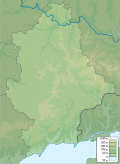
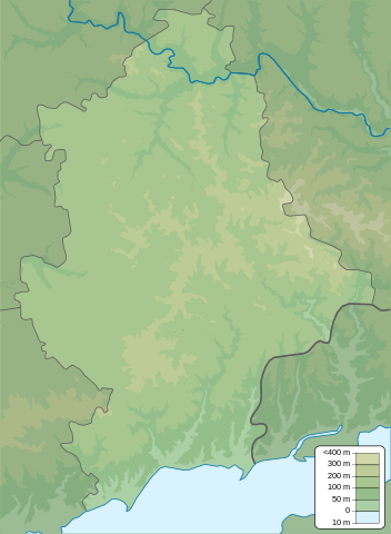
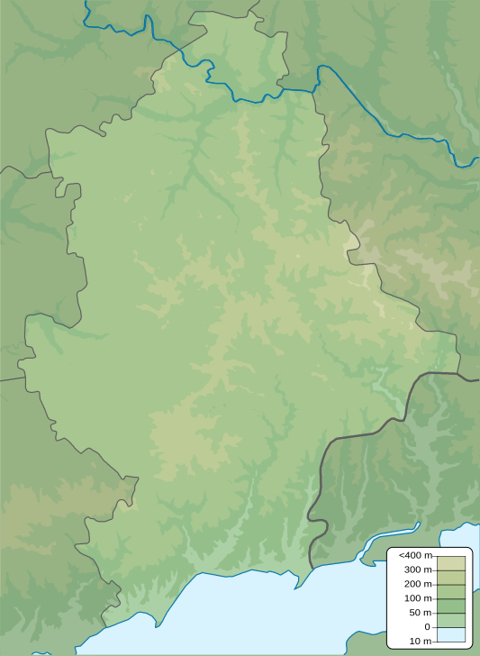
English: Physical map of Donetsk province, Ukraine
Русский: Физическая карта Донецкой области, Украина |
| Date | |
| Source | Own work |
| Author | Urutseg |
Licensing
| I, the copyright holder of this work, release this work into the public domain. This applies worldwide. In some countries this may not be legally possible; if so: I grant anyone the right to use this work for any purpose, without any conditions, unless such conditions are required by law. |
File history
Click on a date/time to view the file as it appeared at that time.
| Date/Time | Thumbnail | Dimensions | User | Comment | |
|---|---|---|---|---|---|
| current | 21:17, 10 December 2010 | | 533 × 727 (581 KB) | Urutseg | == {{int:filedesc}} == {{Information |Description={{en|1=Physical map of Donetsk province, Ukraine}} {{ru|1=Физическая карта Донецкой области, Украина}} |Source={{own}} |Author=Urutseg |Date=2010-12-10 |
File usage
More than 100 pages use this file. The following list shows the first 100 pages that use this file only. A full list is available.
- Andriivka, Myrne settlement hromada, Volnovakha Raion, Donetsk Oblast
- Andriivka (rural settlement), Kramatorsk Raion, Donetsk Oblast
- Avdiivka
- Avdiivka Coke Plant
- Azov, Donetsk Oblast
- Bakhmut
- Bakhmutske
- Battle in Shakhtarsk Raion
- Berestove, Bakhmut Raion, Donetsk Oblast
- Berezove, Volnovakha Raion
- Bezimenne, Kalmiuske Raion
- Bilohorivka, Donetsk Oblast
- Blahodatne, Olhynka settlement hromada, Volnovakha Raion, Donetsk Oblast
- Bohdanivka, Volnovakha Raion, Donetsk Oblast
- Chasiv Yar
- Donetsk
- Donetsk International Airport
- Hladosove
- Hnutove
- Horlivka
- Hranitne, Volnovakha Raion
- Ivanhrad
- Kamianka, Pokrovsk Raion, Donetsk Oblast
- Karpivka, Lyman urban hromada, Kramatorsk Raion, Donetsk Oblast
- Katerynivka, Lyman urban hromada, Kramatorsk Raion, Donetsk Oblast
- Kodema
- Kolodiazi
- Korovii Yar
- Kramatorsk
- Krasnohorivka
- Krasnohorivka, Pokrovsk Raion, Donetsk Oblast
- Krasnyi Kut, Donetsk Oblast
- Kreminets, Kalmiuske Raion
- Kruta Balka, Donetsk Oblast
- Kuteinykove
- Lozove, Bakhmut Raion
- Lyman, Ukraine
- Mariupol
- Meotyda National Nature Park
- Mykolaivka, Volnovakha Raion
- Nevelske
- Nove, Donetsk Oblast
- Novoazovsk
- Novohnativka
- Novoluhanske
- Novomaiorske
- Novoselivka, Ocheretyne settlement hromada, Pokrovsk Raion, Donetsk Oblast
- Novoselivka Druha, Pokrovsk Raion
- Novosilka, Volnovakha Raion
- Novotroitske, Volnovakha Raion, Donetsk Oblast
- Novyi Svit, Donetsk Oblast
- Olenivka, Horlivka Raion, Donetsk Oblast
- Olenivka, Kalmiuske Raion, Donetsk Oblast
- Opytne, Bakhmut Raion, Donetsk Oblast
- Ozerne, Kramatorsk Raion
- Pavlivka, Volnovakha Raion, Donetsk Oblast
- Pavlopil
- Pikuzy
- Pisky, Donetsk Oblast
- Pokrovsk, Ukraine
- Raiske (village), Donetsk Oblast
- Sakhanka
- Serebrianka, Donetsk Oblast
- Shandryholove
- Shchurove
- Shumy
- Shyroka Balka
- Slavne, Kalmiuske Raion, Donetsk Oblast
- Sloviansk
- Soledar
- Solodke, Donetsk Oblast
- Sosnove, Donetsk Oblast
- Spartak, Donetsk Raion
- Spirne, Donetsk Oblast
- Starohnativka
- Staromlynivka
- Staromykhailivka
- Staryi Karavan
- Styla
- Sviatohirsk
- Sviatohirsk Lavra
- Svitlodarsk
- Taramchuk
- Terny, Kramatorsk Raion, Donetsk Oblast
- Troitske, Kramatorsk Raion
- Troitske, Pokrovsk Raion
- Trudivske
- Vasylivka, Pokrovsk Raion, Donetsk Oblast
- Verkhniokamianske
- Verkhnotoretske
- Vesele, Donetsk Raion, Donetsk Oblast
- Vodiane, Mariupol Raion, Donetsk Oblast
- Volnovakha
- Vuhledar
- Yakovlivka, Donetsk Raion
- Yampil, Donetsk Oblast
- Yasynuvata
- Yatskivka
- Zarichne, Donetsk Oblast
- Zelene Pole, Volnovakha Raion
View more links to this file.
Global file usage
The following other wikis use this file:
- Usage on ar.wikipedia.org
- Usage on az.wikipedia.org
- Usage on be.wikipedia.org
- Usage on bg.wikipedia.org
- Usage on bn.wikipedia.org
- Usage on bs.wikipedia.org
- Usage on ca.wikipedia.org
- Usage on ce.wikipedia.org
- Usage on cs.wikipedia.org
- Usage on da.wikipedia.org
- Usage on de.wikipedia.org
- Usage on eo.wikipedia.org
- Usage on es.wikipedia.org
- Usage on fi.wikipedia.org
View more global usage of this file.