
File:Israeli-controlled territories.png
Size of this preview: 322 × 598 pixels. Other resolutions: 129 × 240 pixels | 258 × 480 pixels | 413 × 768 pixels | 551 × 1,024 pixels | 1,998 × 3,712 pixels.
Original file (1,998 × 3,712 pixels, file size: 518 KB, MIME type: image/png)
| This is a file from the Wikimedia Commons. Information from its description page there is shown below. Commons is a freely licensed media file repository. You can help. |
Summary
| Description |
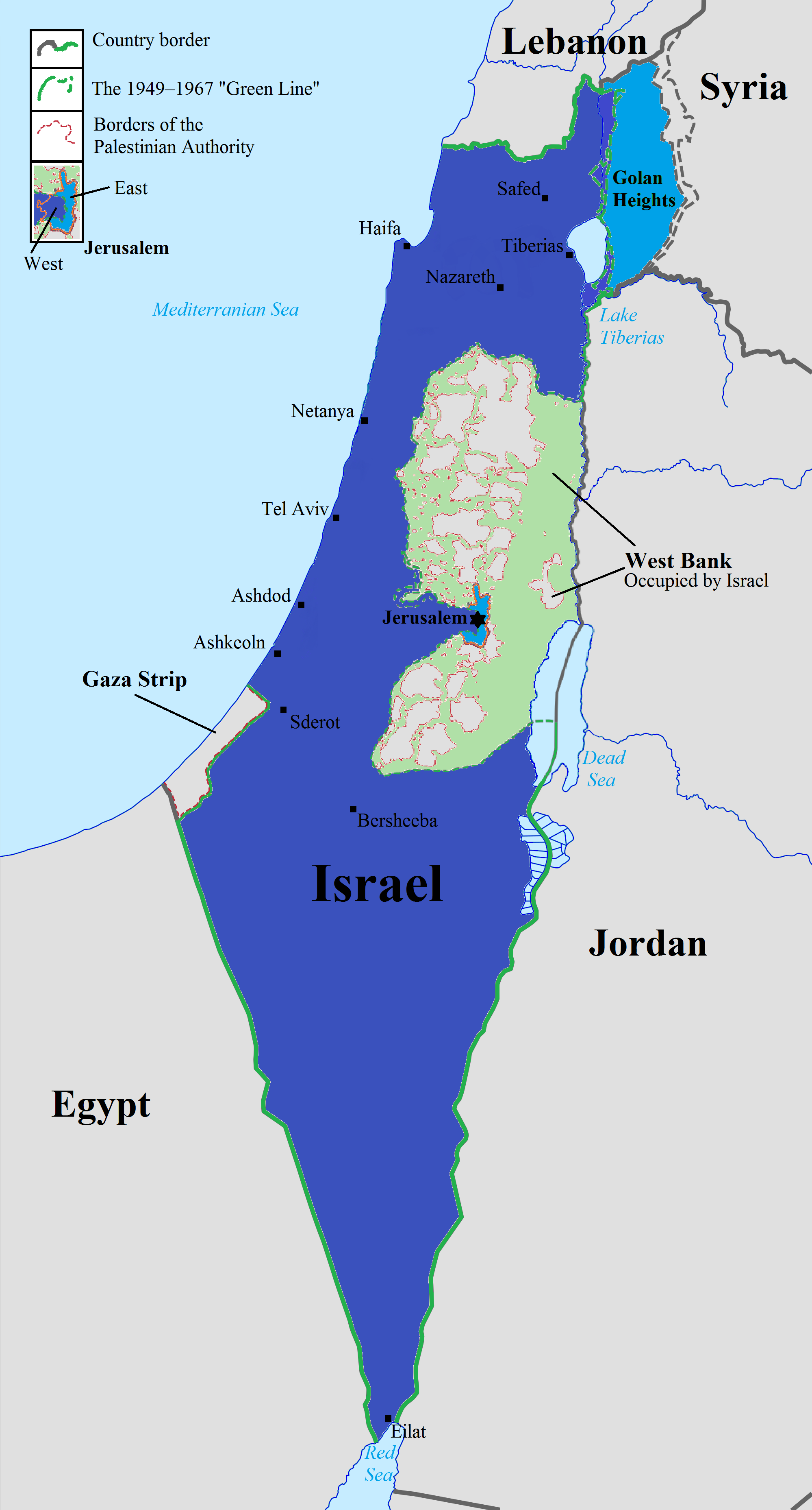
English: The map above illustrates the de facto territorial control by Israel, in relation to the Palestinian Authority and parts of their neighbouring countries. Israel, size when admitted to the United Nations East Jerusalem and the Golan Heights, annexed by Israel Area C of the West Bank, Israeli civil and military control Neighbouring countries, including the Palestinian Authority (West Bank areas A and B have limited self-determination)
This flie was derived from: https://commons.wikimedia.org/wiki/File:Israel_location_map.svg https://commons.wikimedia.org/wiki/File:Zones_A_and_B_in_the_occupied_palestinian_territories.svg http://www.travex.co.il/getting-started/map-2/ |
| Date | |
| Source | Own work |
| Author | Dank Chicken |
Licensing
I, the copyright holder of this work, hereby publish it under the following license:
This file is licensed under the Creative Commons Attribution-Share Alike 4.0 International license.
- You are free:
- to share – to copy, distribute and transmit the work
- to remix – to adapt the work
- Under the following conditions:
- attribution – You must give appropriate credit, provide a link to the license, and indicate if changes were made. You may do so in any reasonable manner, but not in any way that suggests the licensor endorses you or your use.
- share alike – If you remix, transform, or build upon the material, you must distribute your contributions under the same or compatible license as the original.
File history
Click on a date/time to view the file as it appeared at that time.
| Date/Time | Thumbnail | Dimensions | User | Comment | |
|---|---|---|---|---|---|
| current | 14:49, 2 January 2018 | | 1,998 × 3,712 (518 KB) | Dank Chicken | small fixes |
| 14:11, 2 January 2018 |  | 1,998 × 3,712 (481 KB) | Dank Chicken | adding waters and biggest cities | |
| 12:23, 2 January 2018 |  | 2,000 × 3,715 (447 KB) | Dank Chicken | clarifying that all of the west bank is in fact occupied | |
| 12:03, 2 January 2018 |  | 2,000 × 3,715 (444 KB) | Dank Chicken | rest of the text to be explained in-article | |
| 12:28, 31 December 2017 |  | 2,000 × 3,717 (533 KB) | Dank Chicken | New legend | |
| 10:20, 31 December 2017 |  | 2,000 × 3,717 (510 KB) | Dank Chicken | Fixing colours and shades | |
| 11:12, 29 December 2017 |  | 2,000 × 3,717 (590 KB) | Dank Chicken | Different color for E. Jerusalem and Golan per request | |
| 09:36, 22 December 2017 |  | 2,000 × 3,717 (500 KB) | Dank Chicken | Fixing symbols description | |
| 17:56, 21 December 2017 |  | 2,000 × 3,717 (500 KB) | Dank Chicken | Small fixes | |
| 17:07, 21 December 2017 |  | 2,000 × 3,717 (500 KB) | Dank Chicken | Clarifying Israel's internationally recognized borders |
File usage
The following pages on the English Wikipedia use this file (pages on other projects are not listed):