
File:Czoreliefmap1.jpg

Size of this preview: 800 × 584 pixels. Other resolutions: 320 × 234 pixels | 640 × 468 pixels | 1,024 × 748 pixels | 1,080 × 789 pixels.
Original file (1,080 × 789 pixels, file size: 152 KB, MIME type: image/jpeg)
| This is a file from the Wikimedia Commons. Information from its description page there is shown below. Commons is a freely licensed media file repository. You can help. |
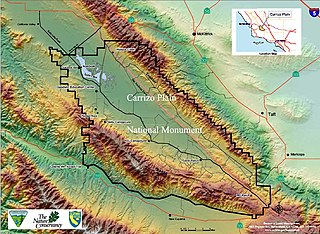
| Description | relief map of Carrizo Plain National Monument, California | |||
| Source | BLM Website http://www.blm.gov/ca/bakersfield/carrizoplain/carrizomonumentmap.html | |||
| Author | BLM Map | |||
| Permission (Reusing this file) |
|
File history
Click on a date/time to view the file as it appeared at that time.
| Date/Time | Thumbnail | Dimensions | User | Comment | |
|---|---|---|---|---|---|
| current | 09:38, 21 January 2007 | | 1,080 × 789 (152 KB) | H-stt | {{Information |Description= relief map of Carrizo Plain National Monument, California |Source= BLM Website http://www.blm.gov/ca/bakersfield/carrizoplain/carrizomonumentmap.html |Date= |Author= BLM Map |Permission= {{PD-USGov-BLM}} |other_versions= }} [[ |
File usage
The following pages on the English Wikipedia use this file (pages on other projects are not listed):
Global file usage
The following other wikis use this file:
- Usage on fr.wikipedia.org
- Usage on nl.wikipedia.org