
File:Cyclades map-fr.svg

Size of this PNG preview of this SVG file: 509 × 600 pixels. Other resolutions: 204 × 240 pixels | 407 × 480 pixels | 652 × 768 pixels | 869 × 1,024 pixels | 1,738 × 2,048 pixels | 3,680 × 4,335 pixels.
Original file (SVG file, nominally 3,680 × 4,335 pixels, file size: 2.74 MB)
| This is a file from the Wikimedia Commons. Information from its description page there is shown below. Commons is a freely licensed media file repository. You can help. |
Summary
| Description |
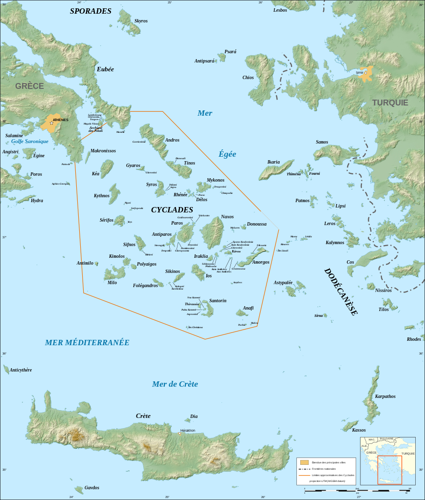
English: Map in French of the Cyclades islands, Greece.
Note: The background map is a raster image embedded in the SVG file. Français : Carte des îles Cyclades, Grèce.
UTM projection ; WGS84 datum ; shaded reliefNote : La carte de fond est une image embarquée dans le fichier SVG. |
||
| Date | |||
| Source |
Own work ;
|
||
| Author | Eric Gaba (Sting - fr:Sting) | ||
| Permission (Reusing this file) |
|
||
| Other versions |
|


|
This SVG file contains embedded text that can be translated into your language, using any capable SVG editor, text editor or the SVG Translate tool. For more information see: About translating SVG files. |
Licensing
I, the copyright holder of this work, hereby publish it under the following licenses:

|
Permission is granted to copy, distribute and/or modify this document under the terms of the GNU Free Documentation License, Version 1.2 or any later version published by the Free Software Foundation; with no Invariant Sections, no Front-Cover Texts, and no Back-Cover Texts. A copy of the license is included in the section entitled GNU Free Documentation License. |
This file is licensed under the Creative Commons Attribution-Share Alike 3.0 Unported, 2.5 Generic, 2.0 Generic and 1.0 Generic license.
- You are free:
- to share – to copy, distribute and transmit the work
- to remix – to adapt the work
- Under the following conditions:
- attribution – You must give appropriate credit, provide a link to the license, and indicate if changes were made. You may do so in any reasonable manner, but not in any way that suggests the licensor endorses you or your use.
- share alike – If you remix, transform, or build upon the material, you must distribute your contributions under the same or compatible license as the original.
You may select the license of your choice.
File history
Click on a date/time to view the file as it appeared at that time.
| Date/Time | Thumbnail | Dimensions | User | Comment | |
|---|---|---|---|---|---|
| current | 17:44, 4 September 2008 | | 3,680 × 4,335 (2.74 MB) | Sting | Fully standardized colors |
| 02:26, 1 September 2008 |  | 3,680 × 4,335 (2.77 MB) | Sting | Little bug | |
| 01:40, 1 September 2008 |  | 3,680 × 4,335 (2.77 MB) | Sting | Some new standard colors | |
| 21:11, 28 September 2007 |  | 3,680 × 4,335 (2.79 MB) | Sting | Typo ; added island names ; Cyclades limits correction | |
| 03:37, 25 September 2007 |  | 3,680 × 4,335 (2.76 MB) | Sting | Text issues | |
| 03:24, 25 September 2007 |  | 3,680 × 4,335 (2.77 MB) | Sting | Again | |
| 03:05, 25 September 2007 |  | 512 × 603 (2.77 MB) | Sting | Map size issues | |
| 02:45, 25 September 2007 |  | 512 × 603 (2.77 MB) | Sting | {{Information |Description=Map in French of the Cyclades islands, Greece |Source=Own work ;<br/>Topographic background map : [http://www2.jpl.nasa.gov/srtm NASA Shuttle Radar Topography Mission] (SRTM3 v.2) (public domain) edited with [http://www.visualiz |
File usage
The following pages on the English Wikipedia use this file (pages on other projects are not listed):
Global file usage
The following other wikis use this file:
- Usage on ca.wikipedia.org
- Usage on es.wikipedia.org
- Usage on et.wikipedia.org
- Usage on pt.wikibooks.org
- Usage on uk.wikipedia.org