
File:CumberlandGapMap.jpg

Size of this preview: 800 × 410 pixels. Other resolutions: 320 × 164 pixels | 640 × 328 pixels | 1,170 × 599 pixels.
Original file (1,170 × 599 pixels, file size: 141 KB, MIME type: image/jpeg)
| This is a file from the Wikimedia Commons. Information from its description page there is shown below. Commons is a freely licensed media file repository. You can help. |
Summary
| Description |
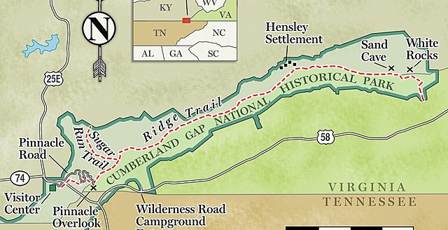
English: Trail map of the Cumberland Gap National Historical Park |
| Date | Unknown date |
| Source | Photo taken from https://scoutingmagazine.org/2017/02/plan-trip-cumberland-gap-national-historic-park/ |
| Author | Image credited to the National Park Service |
Licensing
| This image or media file contains material based on a work of a National Park Service employee, created as part of that person's official duties. As a work of the U.S. federal government, such work is in the public domain in the United States. See the NPS website and NPS copyright policy for more information. |
File history
Click on a date/time to view the file as it appeared at that time.
| Date/Time | Thumbnail | Dimensions | User | Comment | |
|---|---|---|---|---|---|
| current | 18:50, 6 April 2018 | | 1,170 × 599 (141 KB) | GreenMeansGo | User created page with UploadWizard |
File usage
The following pages on the English Wikipedia use this file (pages on other projects are not listed):