
File:Colonisation 1885.png

Original file (1,200 × 526 pixels, file size: 206 KB, MIME type: image/png)
| This is a file from the Wikimedia Commons. Information from its description page there is shown below. Commons is a freely licensed media file repository. You can help. |
| Description |
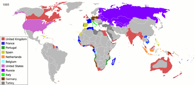
Map of major world powers by year, derived from public domain animated map on wikipedia.
As the orriginal licence of the animation was Public Domain, this image which has been derived from it is too:
|
||||||||||||||||||
| Date | |||||||||||||||||||
| Source | public domain animated map by ArdadN here | ||||||||||||||||||
| Author | ArdadN | ||||||||||||||||||
.jpg)
._LOC_2001620596.jpg)

|
This historical map image could be re-created using vector graphics as an SVG file. This has several advantages; see Commons:Media for cleanup for more information. If an SVG form of this image is available, please upload it and afterwards replace this template with
{{vector version available|new image name}}.
It is recommended to name the SVG file “Colonisation 1885.svg”—then the template Vector version available (or Vva) does not need the new image name parameter. |
File history
Click on a date/time to view the file as it appeared at that time.
| Date/Time | Thumbnail | Dimensions | User | Comment | |
|---|---|---|---|---|---|
| current | 09:05, 8 November 2021 | | 1,200 × 526 (206 KB) | Randomastwritter | jubaland |
| 09:52, 5 April 2020 |  | 1,200 × 526 (206 KB) | Ориенталист | South Sakhalin was part of Russia in 1885 | |
| 11:17, 2 May 2015 |  | 1,425 × 625 (49 KB) | Chrischerf | German Empire and colonies in 1885; Sudan under control of the Mahdi | |
| 02:57, 3 August 2014 |  | 1,425 × 625 (54 KB) | Alvin Lee | correcting the boundaries of Russia and China | |
| 13:54, 3 November 2013 |  | 1,425 × 625 (78 KB) | McZusatz | Reverted to version as of 00:22, 24 January 2011 [corrupt file?] | |
| 15:24, 3 November 2012 |  | 1,425 × 625 (67 KB) | Franco310397 | Spanish presence in Micronesia (Oceania) included in the Captaincy General of the Philippines. In the Caroline Islands and the Mariana Islands. | |
| 00:22, 24 January 2011 |  | 1,425 × 625 (78 KB) | Micsha~commonswiki | Reverted to version as of 02:17, 3 May 2010 | |
| 00:22, 24 January 2011 |  | 506 × 326 (85 KB) | Micsha~commonswiki | Only Africa; includes map key | |
| 02:17, 3 May 2010 |  | 1,425 × 625 (78 KB) | Kieran4 | slight edit | |
| 02:14, 3 May 2010 |  | 1,425 × 625 (78 KB) | Kieran4 | Correct Dutch East INdies |
File usage
Global file usage
The following other wikis use this file:
- Usage on am.wikipedia.org
- Usage on de.wikipedia.org
- Usage on es.wikipedia.org
- Usage on fr.wikipedia.org
- Usage on he.wikipedia.org
- Usage on oc.wikipedia.org
- Usage on sk.wikipedia.org