
File:Clarion River bridge in Licking Township.jpg

Size of this preview: 800 × 450 pixels. Other resolutions: 320 × 180 pixels | 640 × 360 pixels | 1,024 × 576 pixels | 1,280 × 720 pixels | 2,816 × 1,584 pixels.
Original file (2,816 × 1,584 pixels, file size: 1.63 MB, MIME type: image/jpeg)
| This is a file from the Wikimedia Commons. Information from its description page there is shown below. Commons is a freely licensed media file repository. You can help. |
| Camera location | | View this and other nearby images on: OpenStreetMap |
|---|
| Description |
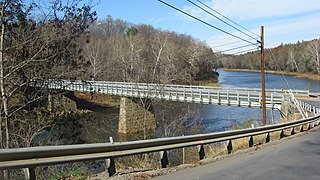
English: View from the south of the bridge that carries Pennsylvania Route 58 over the Clarion River just north of Callensburg in Licking Township, Clarion County, Pennsylvania, United States. |
||
| Date | Taken on 4 November 2014 | ||
| Source | Own work | ||
| Author | Nyttend | ||
| Permission (Reusing this file) |
|
File history
Click on a date/time to view the file as it appeared at that time.
| Date/Time | Thumbnail | Dimensions | User | Comment | |
|---|---|---|---|---|---|
| current | 04:14, 13 November 2014 | | 2,816 × 1,584 (1.63 MB) | Nyttend | {{Location|41|7|48|N|79|33|16|W}} {{Information |Description={{en|View from the south of the bridge that carries {{w|Pennsylvania Route 58}} over the {{w|Clarion River}} just north of {{w|Callensburg, Pennsylvania|Callensburg}} in {{w|Licking Township,... |
File usage
The following pages on the English Wikipedia use this file (pages on other projects are not listed):
Global file usage
The following other wikis use this file:
- Usage on cy.wikipedia.org
- Usage on de.wikipedia.org
- Usage on es.wikipedia.org
- Usage on fr.wikipedia.org
- Usage on uk.wikipedia.org
- Usage on ur.wikipedia.org
- Usage on vi.wikipedia.org
- Usage on www.wikidata.org