
File:Castles of Munster, Ardfinnan, Tipperary - geograph.org.uk - 1393364.jpg
Size of this preview: 800 × 534 pixels. Other resolutions: 320 × 213 pixels | 640 × 427 pixels | 1,024 × 683 pixels.
Original file (1,024 × 683 pixels, file size: 975 KB, MIME type: image/jpeg)
| This is a file from the Wikimedia Commons. Information from its description page there is shown below. Commons is a freely licensed media file repository. You can help. |
Summary
| Description |
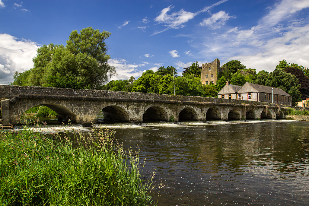
English: Castles of Munster: Ardfinnan, Tipperary. The original castle was built by Prince John in 1185, and after being taken by General Ireton, was garrisoned by Cromwellian troops throughout the 1650s. The castle was restored and rebuilt in the 18c and 19c, with the exception of a 15c tower. The castle together with the ancient bridge over the River Suir make an attractive group. |
| Date | |
| Source | From geograph.org.uk |
| Author | Mike Searle |
| Attribution (required by the license) | Mike Searle / Castles of Munster: Ardfinnan, Tipperary / |
| Camera location | | View this and other nearby images on: OpenStreetMap |
|---|
_heading:315.00&language=en)
| Object location | | View this and other nearby images on: OpenStreetMap |
|---|
_heading:315.00&language=en)
Licensing

|
This image was taken from the Geograph project collection. See this photograph's page on the Geograph website for the photographer's contact details. The copyright on this image is owned by Mike Searle and is licensed for reuse under the Creative Commons Attribution-ShareAlike 2.0 license.
|
This file is licensed under the Creative Commons Attribution-Share Alike 2.0 Generic license.
Attribution: Mike Searle
- You are free:
- to share – to copy, distribute and transmit the work
- to remix – to adapt the work
- Under the following conditions:
- attribution – You must give appropriate credit, provide a link to the license, and indicate if changes were made. You may do so in any reasonable manner, but not in any way that suggests the licensor endorses you or your use.
- share alike – If you remix, transform, or build upon the material, you must distribute your contributions under the same or compatible license as the original.
File history
Click on a date/time to view the file as it appeared at that time.
| Date/Time | Thumbnail | Dimensions | User | Comment | |
|---|---|---|---|---|---|
| current | 13:28, 10 February 2019 | | 1,024 × 683 (975 KB) | Geograph Update Bot | Higher-resolution version from Geograph. |
| 21:31, 28 February 2011 |  | 640 × 431 (358 KB) | GeographBot | == {{int:filedesc}} == {{Information |description={{en|1=Castles of Munster: Ardfinnan, Tipperary The original castle was built by Prince John in 1185, and after being taken by General Ireton, was garrisoned by Cromwellian troops throughout the 1650s. The |
File usage
The following pages on the English Wikipedia use this file (pages on other projects are not listed):
Global file usage
The following other wikis use this file:
- Usage on ca.wikipedia.org
- Usage on en.wikiquote.org
- Usage on fa.wikipedia.org
- Usage on ga.wikipedia.org
- Usage on gl.wikipedia.org
- Usage on no.wikipedia.org
- Usage on uk.wikipedia.org
- Usage on www.wikidata.org