
File:Carte Phrygie.png
No higher resolution available.
Carte_Phrygie.png (483 × 444 pixels, file size: 59 KB, MIME type: image/png)
| This is a file from the Wikimedia Commons. Information from its description page there is shown below. Commons is a freely licensed media file repository. You can help. |
Summary
| Description |
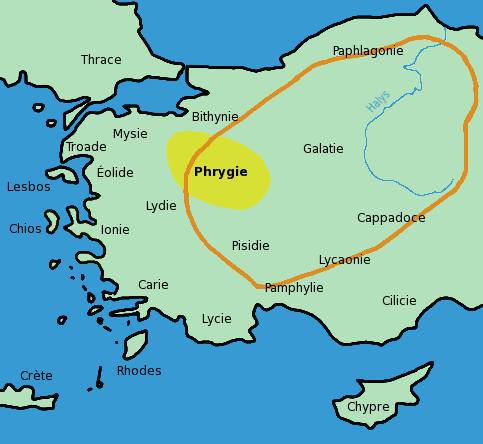
English: Map showing the traditional region of Phrygia and the manimum expansion of Phrygian kingdom in French. Adaptated from Image:Turkey ancient region map phrygia.jpg.
Français : Carte montrant l'emplacement de la région traditionnelle de Phrygie (jaune) et l'expansion maximale du royaume Phrygien (orange). Traduite et adaptée de Image:Turkey ancient region map phrygia.jpg. |
| Source | Own work |
| Author | Bibi Saint-Pol |
Licensing
I, the copyright holder of this work, hereby publish it under the following licenses:

|
Permission is granted to copy, distribute and/or modify this document under the terms of the GNU Free Documentation License, Version 1.2 or any later version published by the Free Software Foundation; with no Invariant Sections, no Front-Cover Texts, and no Back-Cover Texts. A copy of the license is included in the section entitled GNU Free Documentation License. |
| This file is licensed under the Creative Commons Attribution-Share Alike 3.0 Unported license. | ||
| ||
| This licensing tag was added to this file as part of the GFDL licensing update. |
This file is licensed under the Creative Commons Attribution-Share Alike 2.5 Generic, 2.0 Generic and 1.0 Generic license.
- You are free:
- to share – to copy, distribute and transmit the work
- to remix – to adapt the work
- Under the following conditions:
- attribution – You must give appropriate credit, provide a link to the license, and indicate if changes were made. You may do so in any reasonable manner, but not in any way that suggests the licensor endorses you or your use.
- share alike – If you remix, transform, or build upon the material, you must distribute your contributions under the same or compatible license as the original.
You may select the license of your choice.
File history
Click on a date/time to view the file as it appeared at that time.
| Date/Time | Thumbnail | Dimensions | User | Comment | |
|---|---|---|---|---|---|
| current | 14:11, 29 August 2006 | | 483 × 444 (59 KB) | Bibi Saint-Pol | décalage Mysie |
| 13:52, 29 August 2006 |  | 483 × 444 (59 KB) | Bibi Saint-Pol | == Summary == {{en|Map showing the traditional region of Phrygia and the manimum expansion of Phrygian kingdom in French. Adaptated from Image:Turkey ancient region map phrygia.jpg.}} {{fr|Carte montrant l'emplacement de la région traditionnelle de |
File usage
The following pages on the English Wikipedia use this file (pages on other projects are not listed):
Global file usage
The following other wikis use this file:
- Usage on fr.wikipedia.org
- Usage on fr.wiktionary.org
- Usage on ga.wikipedia.org
- Usage on he.wikipedia.org
- Usage on la.wikipedia.org
- Usage on mg.wikipedia.org
- Usage on nl.wikipedia.org
- Usage on oc.wikipedia.org
- Usage on pl.wikipedia.org
- Usage on pt.wikipedia.org
- Usage on ru.wikipedia.org
- Usage on uk.wikipedia.org