
File:CapeChidleyAreaMap.png

Size of this preview: 430 × 600 pixels. Other resolutions: 172 × 240 pixels | 539 × 752 pixels.
Original file (539 × 752 pixels, file size: 19 KB, MIME type: image/png)
| This is a file from the Wikimedia Commons. Information from its description page there is shown below. Commons is a freely licensed media file repository. You can help. |
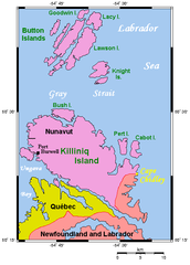
Summary
From en:Image:CapeChidleyAreaMap.png.
Uploaded by Kelisi ,01:34, 23 March 2006.
A map of Cape Chidley and nearby areas in Québec, Newfoundland and Labrador, and Nunavut. This map's source is here archive copy at the Wayback Machine, with the uploader's modifications, and the GMT homepage archive copy at the Wayback Machine says that the tools are released under the GNU General Public License.
Licensing

|
Permission is granted to copy, distribute and/or modify this document under the terms of the GNU Free Documentation License, Version 1.2 or any later version published by the Free Software Foundation; with no Invariant Sections, no Front-Cover Texts, and no Back-Cover Texts. A copy of the license is included in the section entitled GNU Free Documentation License. |
| This file is licensed under the Creative Commons Attribution-Share Alike 3.0 Unported license. | ||
| ||
| This licensing tag was added to this file as part of the GFDL licensing update. |
File history
Click on a date/time to view the file as it appeared at that time.
| Date/Time | Thumbnail | Dimensions | User | Comment | |
|---|---|---|---|---|---|
| current | 15:55, 26 February 2007 | | 539 × 752 (19 KB) | Nopira | From en:Image:CapeChidleyAreaMap.png. Uploaded by Kelisi ,01:34, 23 March 2006. A map of Cape Chidley and nearby areas in Québec, Newfoundland and Labrador, and Nunavut. This map's source is [http://www.aquarius.geomar.de/omc/make_map.html here], |
File usage
The following pages on the English Wikipedia use this file (pages on other projects are not listed):
Global file usage
The following other wikis use this file:
- Usage on bg.wikipedia.org
- Usage on ca.wikipedia.org
- Usage on ceb.wikipedia.org
- Usage on ckb.wikipedia.org
- Usage on da.wikipedia.org
- Usage on de.wikipedia.org
- Usage on es.wikipedia.org
- Usage on fa.wikipedia.org
- Usage on fr.wikipedia.org
- Usage on it.wikipedia.org
- Usage on ja.wikipedia.org
- Usage on ml.wikipedia.org
- Usage on nl.wikipedia.org
- Usage on no.wikipedia.org
- Usage on pl.wikipedia.org
- Usage on pt.wikipedia.org
- Usage on ru.wikipedia.org
- Usage on sv.wikipedia.org
- Usage on www.wikidata.org