
File:Capannone bramme - area ex Falck Unione 02.JPG

Original file (2,560 × 1,920 pixels, file size: 1.95 MB, MIME type: image/jpeg)
| This is a file from the Wikimedia Commons. Information from its description page there is shown below. Commons is a freely licensed media file repository. You can help. |
Summary
| Description |
Italiano: Comparto Unione area ex-Falck
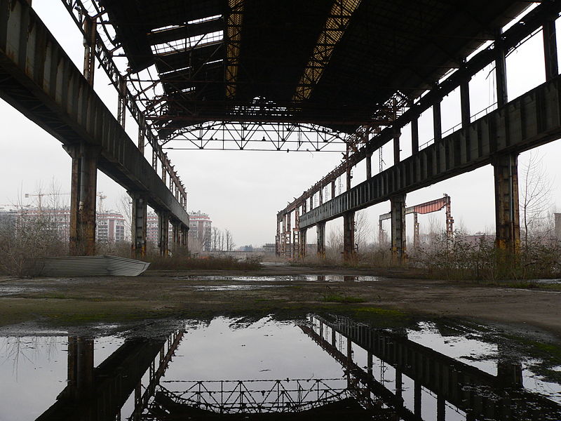
Capannone bramme Questo capannone faceva parte dello stabilimento Falck Unione di sesto San Giovanni, Era il capannone di raccordo tra l’Acciaieria con i forni a fiamma Martin-Siemens, l’Acciaieria con i forni elettrici e il reparto Laminatoio, che comprendeva tutta l’area fino alla ferrovia con confine a nord su via Trento. Dal 1983, anno in cui cessa la produzione dei lingotti, fino alla chiusura, l’edificio era usato come parco per le bramme prodotte all’impianto di colata continua. Le bramme sono dei semilavorati a sezione rettangolare con spigoli arrotondati, destinate a lavorazioni successive. Da qui le bramme venivano avviate al forno a barre mobili del treno nastro o a operazioni di controllo e condizionamento. All’Unione le bramme servivano per produrre il nastro. In questo capannone le bramme erano sottoposte a controlli e a operazioni di condizionatura per rimuovere i difetti. La parte più a nord del capannone (lato Monza) era l’area di scarico e deposito dei rotoli di nastro prodotti al Laminatoio. Il capannone bramme sorge oggi in un'area dismessa. E' tutelato dal PGT del Comune di Sesto San Giovanni come bene storico documentale e rientra tra gli edifici del progetto di candidatura di Sesto per l'UNESCO per la categoria del paesaggio culturale evolutivo.
|
||
| Date | |||
| Source | Own work | ||
| Author | Cristina meneguzzo |
| Camera location | | View this and other nearby images on: OpenStreetMap |
|---|
Licensing
- You are free:
- to share – to copy, distribute and transmit the work
- to remix – to adapt the work
- Under the following conditions:
- attribution – You must give appropriate credit, provide a link to the license, and indicate if changes were made. You may do so in any reasonable manner, but not in any way that suggests the licensor endorses you or your use.
- share alike – If you remix, transform, or build upon the material, you must distribute your contributions under the same or compatible license as the original.

|
This image was uploaded as part of Wiki Loves Monuments 2013.
|
 |
File history
Click on a date/time to view the file as it appeared at that time.
| Date/Time | Thumbnail | Dimensions | User | Comment | |
|---|---|---|---|---|---|
| current | 19:37, 21 September 2013 | | 2,560 × 1,920 (1.95 MB) | Cristina meneguzzo | User created page with UploadWizard |
File usage
Global file usage
The following other wikis use this file:
- Usage on de.wikipedia.org
- Usage on it.wikipedia.org
- Usage on it.wikivoyage.org