
File:CROMWELL’S QUARTERS AT BOW BRIDGE DUBLIN (WAS MURDERING LANE AND MAYBE THE FORTY STEPS)-162441.jpg

Original file (5,424 × 3,616 pixels, file size: 16.47 MB, MIME type: image/jpeg)
| This is a file from the Wikimedia Commons. Information from its description page there is shown below. Commons is a freely licensed media file repository. You can help. |
-162441.jpg)
Summary
| Description |
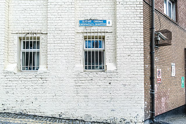
English: Cromwell was never too popular in Ireland so the name of this alleyway is surprising.
When I was young I went to school in Dublin City Centre and as we finished school at 12:30 every Wednesday I got plenty of opportunity to explore most parts of the city and back I knew this stepped laneway well. Back then I was convinced that this lane was the ‘forty steps’. More recently I believed that it was “Murdering Lane” because when I went on a walking tour a few years ago the guide told us that it was Murdering Lane. Back then I did not notice the street sign indicating that it is currently known as Cromwell’S Quarters. [Note: the sign was stolen and was not replaced for five years]. After some research I discovered that it was renamed in 1892 so the information supplied by the guide was well out of date. In the 1862 edition of Tom’s Almanac it is listed as Murdering Lane. I also came across the following: “Cut-throat Lane and Murdering Lane were two adjoining streets in Mount-Brown. The name Cut-throat Lane, which was in existence as far back as 1488, was changed to Roundhead Row in 1876 and Murdering Lane was changed to Cromwell's Quarter”. I cannot remember the source of this quote. Another source informed me that there was a Cut-Throat Lane East’ and a ‘Cut-Throat Lane West’. Selling a house in those days could not have been easy with names like this. A map, produced by the George’s Street Business Association (GSBA), recommends a climb up the Forty Steps beside Dublin Castle. In fact there are only 39 steps. Here is a link to the map www.georgesstreet.ie/flyer-web.pdf I had intend to return to Cromwell’s Quarters in order to count the steps but this time I forgot to do so. |
| Date | |
| Source | https://www.flickr.com/photos/infomatique/49978279867/ |
| Author | William Murphy |
Licensing
- You are free:
- to share – to copy, distribute and transmit the work
- to remix – to adapt the work
- Under the following conditions:
- attribution – You must give appropriate credit, provide a link to the license, and indicate if changes were made. You may do so in any reasonable manner, but not in any way that suggests the licensor endorses you or your use.
- share alike – If you remix, transform, or build upon the material, you must distribute your contributions under the same or compatible license as the original.
| This image was originally posted to Flickr by infomatique at https://flickr.com/photos/80824546@N00/49978279867. It was reviewed on 12 June 2020 by FlickreviewR 2 and was confirmed to be licensed under the terms of the cc-by-sa-2.0. |
File history
Click on a date/time to view the file as it appeared at that time.
| Date/Time | Thumbnail | Dimensions | User | Comment | |
|---|---|---|---|---|---|
| current | 16:54, 12 June 2020 | | 5,424 × 3,616 (16.47 MB) | Financefactz | Uploaded a work by William Murphy from https://www.flickr.com/photos/infomatique/49978279867/ with UploadWizard |
File usage
Global file usage
The following other wikis use this file:
- Usage on ru.wikipedia.org
-162441.jpg)