
File:British main lines railway diagram.png

Size of this preview: 421 × 599 pixels. Other resolutions: 168 × 240 pixels | 337 × 480 pixels | 539 × 768 pixels | 719 × 1,024 pixels | 2,464 × 3,508 pixels.
Original file (2,464 × 3,508 pixels, file size: 558 KB, MIME type: image/png)
| This is a file from the Wikimedia Commons. Information from its description page there is shown below. Commons is a freely licensed media file repository. You can help. |

|
File:British main lines railway diagram.svg is a vector version of this file. It should be used in place of this PNG file when not inferior.
File:British main lines railway diagram.png → File:British main lines railway diagram.svg
For more information, see Help:SVG. |
 |
Summary
| Description |
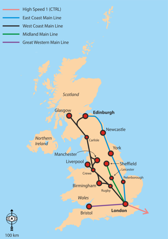
English: Simple overview map of the WCML, ECML, Midland Main Line and CTRL. |
| Date | |
| Source | Own work |
| Author | Classical geographer |
Background is File:Uk_outline_map.png; ECML and WCML are based on File:Uk outline map with ECML railway.PNG and File:Uk outline map with WCML railway.PNG.
Licensing
I, the copyright holder of this work, hereby publish it under the following license:
This file is licensed under the Creative Commons Attribution-Share Alike 3.0 Unported license.
- You are free:
- to share – to copy, distribute and transmit the work
- to remix – to adapt the work
- Under the following conditions:
- attribution – You must give appropriate credit, provide a link to the license, and indicate if changes were made. You may do so in any reasonable manner, but not in any way that suggests the licensor endorses you or your use.
- share alike – If you remix, transform, or build upon the material, you must distribute your contributions under the same or compatible license as the original.
File history
Click on a date/time to view the file as it appeared at that time.
| Date/Time | Thumbnail | Dimensions | User | Comment | |
|---|---|---|---|---|---|
| current | 17:29, 6 September 2016 | | 2,464 × 3,508 (558 KB) | Rob984 | Showing all of Ireland but not even part of France is odd. Especially considering there are UK-France high speed routes. |
| 04:48, 6 September 2016 |  | 2,503 × 3,627 (849 KB) | Classical geographer | Added Western Main Line. Decreased font size of junctions. Note the map is still intended for a quick overview, perhaps at the top of an article. | |
| 07:29, 22 July 2010 |  | 1,333 × 1,777 (188 KB) | Classical geographer | Chester should have been Crewe. | |
| 19:17, 21 July 2010 |  | 1,666 × 2,221 (904 KB) | Classical geographer | Resized, because was over 12.5 million pixels. | |
| 19:15, 21 July 2010 |  | 3,333 × 4,444 (600 KB) | Classical geographer | {{Information |Description={{en|1=Simple overview map of the WCML, ECML, Midland Main Line and CTRL.}} |Source={{own}} |Author=Classical geographer |Date=2010-07-21 |Permission= |other_versions= }} Background is [[:File:Uk_ou |
File usage
The following pages on the English Wikipedia use this file (pages on other projects are not listed):
Global file usage
The following other wikis use this file:
- Usage on fa.wikipedia.org
- Usage on it.wikipedia.org
- Usage on ja.wikipedia.org
- Usage on nl.wikipedia.org
- Usage on no.wikipedia.org
- Usage on pnb.wikipedia.org
- Usage on pt.wikipedia.org
- Usage on ru.wikipedia.org
- Usage on ur.wikipedia.org
- Usage on zh.wikipedia.org