
File:Bottom of 20 District Slope Shaft - geograph.org.uk - 318612.jpg
No higher resolution available.
Bottom_of_20_District_Slope_Shaft_-_geograph.org.uk_-_318612.jpg (640 × 436 pixels, file size: 46 KB, MIME type: image/jpeg)
| This is a file from the Wikimedia Commons. Information from its description page there is shown below. Commons is a freely licensed media file repository. You can help. |
Summary
| Description |
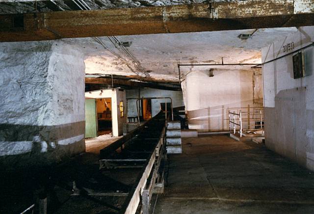
English: Bottom of 20 District Slope Shaft 20 District of the ammunition depot also falls within this grid square, here is a photo taken in the early 1980's before any real damage has been done.
The picture shows the conveyor heading to the shaft with a step over point, an office on the left and the barrier around the sewage ejector on the right. The trunking on the ceiling was for the air conditioning. |
| Date | |
| Source | From geograph.org.uk |
| Author | Derek Hawkins |
| Attribution (required by the license) | Derek Hawkins / Bottom of 20 District Slope Shaft / |
| Camera location | | View this and other nearby images on: OpenStreetMap |
|---|
_heading:67.00&language=en)
| Object location | | View this and other nearby images on: OpenStreetMap |
|---|
_heading:67.00&language=en)
Licensing

|
This image was taken from the Geograph project collection. See this photograph's page on the Geograph website for the photographer's contact details. The copyright on this image is owned by Derek Hawkins and is licensed for reuse under the Creative Commons Attribution-ShareAlike 2.0 license.
|
This file is licensed under the Creative Commons Attribution-Share Alike 2.0 Generic license.
Attribution: Derek Hawkins
- You are free:
- to share – to copy, distribute and transmit the work
- to remix – to adapt the work
- Under the following conditions:
- attribution – You must give appropriate credit, provide a link to the license, and indicate if changes were made. You may do so in any reasonable manner, but not in any way that suggests the licensor endorses you or your use.
- share alike – If you remix, transform, or build upon the material, you must distribute your contributions under the same or compatible license as the original.
File history
Click on a date/time to view the file as it appeared at that time.
| Date/Time | Thumbnail | Dimensions | User | Comment | |
|---|---|---|---|---|---|
| current | 14:33, 30 December 2010 | | 640 × 436 (46 KB) | GeographBot | == {{int:filedesc}} == {{Information |description={{en|1=Bottom of 20 District Slope Shaft 20 District of the ammunition depot also falls within this grid square, here is a photo taken in the early 1980's before any real damage has been done. The picture |
File usage
The following pages on the English Wikipedia use this file (pages on other projects are not listed):