File:Bherwerre Parish NSW.jpg

Page contents not supported in other languages.
This is a file from the Wikimedia Commons
From Wikipedia, the free encyclopedia

Original file(2,572 × 2,256 pixels, file size: 863 KB, MIME type: image/jpeg)

Description

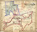
Map of the Parish of Bherwerre, County of St. Vincent, New South Wales.

 
Boundary of the parish since 1915
 
Parts of the parish which were transferred to the Commonwealth for the Jervis Bay Territory in 1915.
Date 1912. (some writing on the map dates to late 1910s but still before copyright would apply)
Source New South Wales Department of Lands Parish map preservation project. [1]
Author Dept. of Lands Sydney
Permission
(Reusing this file)

govt map, copyright expires 50 years after it was made [2] (it was also out of copyright in 1996 and so is not copyrighted in the US), so:

Public domain
This image or other work is of Australian origin and is now in the public domain because its term of copyright has expired. According to the Australian Copyright Council (ACC), ACC Information Sheet G023v19 (Duration of copyright) (January 2019).1
Type of materialCopyright has expired if …
 A Photographs or other works published anonymously, under a pseudonym or the creator is unknown: taken or published prior to 1 January 1955
BPhotographs (except A): taken prior to 1 January 1955
CArtistic works (except A & B): the creator died before 1 January 1955
DPublished editions2 (except A & B): first published more than 25 years ago
ECommonwealth, State or Territory owned3 photographs and engravings: taken or published more than 50 years ago
1 Copyright Amendment (Disability Access and Other Measures) Bill 2017 (Australian Government)
2 means the typographical arrangement and layout of a published work. eg. newsprint.
3 owned means where a government is the copyright owner as well as would have owned copyright but reached some other agreement with the creator.
When using this template, please provide information of where the image was first published and who created it.

You must also include a United States public domain tag to indicate why this work is in the public domain in the United States.
العربية  català  Deutsch  English  español  français  日本語  македонски  മലയാളം  Nederlands  русский  slovenščina  Tok Pisin  Türkçe  українська  简体中文  繁體中文  +/−
Australia
Australia

Captions

Add a one-line explanation of what this file represents

Items portrayed in this file

depicts

image/jpeg

06c0219c41bbd69500b5084058fe959fd31b5a53

883,898 byte

2,256 pixel

2,572 pixel

File history

Click on a date/time to view the file as it appeared at that time.

Date/TimeThumbnailDimensionsUserComment
current09:26, 22 September 2007Thumbnail for version as of 09:26, 22 September 20072,572 × 2,256 (863 KB)Roke~commonswiki{{Information |Description=Map of the Parish of Bherwerre, County of St. Vincent, New South Wales. {{legend|#130eff|Boundary of the parish since 1915}} {{legend
The following pages on the English Wikipedia use this file (pages on other projects are not listed):

Metadata