
File:Bernina-Alpen.png

Size of this preview: 800 × 591 pixels. Other resolutions: 320 × 236 pixels | 640 × 473 pixels | 1,024 × 757 pixels | 1,280 × 946 pixels | 2,560 × 1,891 pixels | 4,917 × 3,633 pixels.
Original file (4,917 × 3,633 pixels, file size: 3.2 MB, MIME type: image/png)
| This is a file from the Wikimedia Commons. Information from its description page there is shown below. Commons is a freely licensed media file repository. You can help. |
Summary
| Description |
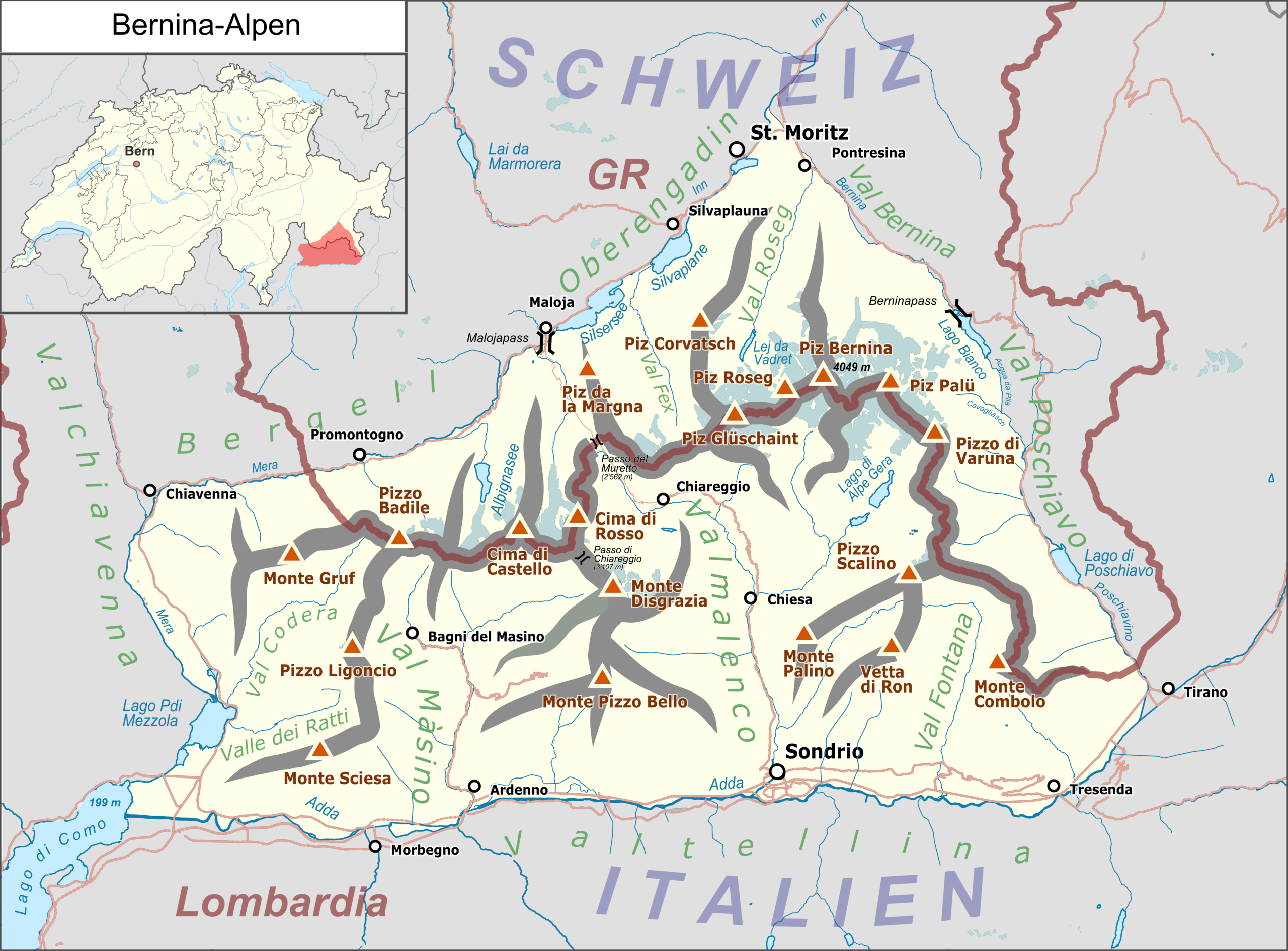
Deutsch: Lagekarte der Bernina-Alpen. |
|||||||||
| Date | ||||||||||
| Source |
Own work Map was created using:
|
|||||||||
| Creator | ||||||||||
| Permission (Reusing this file) |
Map data (c) OpenStreetMap (and) contributors, CC-BY-SA | |||||||||
| Geotemporal data | ||||||||||
| Bounding box |
|
|||||||||
| Georeferencing | ||||||||||
Licensing
I, the copyright holder of this work, hereby publish it under the following license:
This file is licensed under the Creative Commons Attribution 3.0 Unported license.
- You are free:
- to share – to copy, distribute and transmit the work
- to remix – to adapt the work
- Under the following conditions:
- attribution – You must give appropriate credit, provide a link to the license, and indicate if changes were made. You may do so in any reasonable manner, but not in any way that suggests the licensor endorses you or your use.
| This work is licensed under the Open Database License (summary). |
File history
Click on a date/time to view the file as it appeared at that time.
| Date/Time | Thumbnail | Dimensions | User | Comment | |
|---|---|---|---|---|---|
| current | 05:04, 3 June 2017 | | 4,917 × 3,633 (3.2 MB) | Pechristener | corrections: Val Fontana, location of Berninapass, Val Fex |
| 19:23, 20 May 2017 |  | 4,917 × 3,633 (3.21 MB) | Pechristener | the border of the previous version was correct. Passo di Chiareggio added. Acqua da Pila and Cavagliasch added. | |
| 03:24, 9 May 2017 |  | 1,324 × 978 (638 KB) | Pechristener | kleine Reparatur an der Ostgrenze beim Berninapass | |
| 16:36, 24 October 2016 |  | 1,324 × 978 (643 KB) | Pechristener | niedrigsten Höhe, Murettapass und Namen der Täler eingetragen | |
| 18:32, 16 October 2016 |  | 1,324 × 978 (578 KB) | Pechristener | {{Map |Description={{de|1=Lagekarte der Bernina-Alpen}} |Source ={{own}} Map was created using: *[http://www.openstreetmap.org/ Open Street Map] *Switzerland location map.svg for locati... |
File usage
The following pages on the English Wikipedia use this file (pages on other projects are not listed):
Global file usage
The following other wikis use this file:
- Usage on als.wikipedia.org
- Usage on de.wikipedia.org
- Berninapass
- Piz Bernina
- Morteratschgletscher
- Piz Badile
- Fornogletscher
- Persgletscher
- Albignasee
- Monte Disgrazia
- Piz Zupò
- Piz Corvatsch
- Diavolezza
- Piz Morteratsch
- Bernina-Alpen
- Murettopass
- Liste der Gebirgsgruppen in den Ostalpen (nach AVE)
- Munt Pers
- Piz Boval
- Bovalhütte
- Tschiervahütte
- Crast’ Agüzza
- Coazhütte
- Piz Cengalo
- Piz Tschierva
- Albignahütte
- Fornohütte
- Piz Bacun
- Vorlage:Positionskarte Bernina-Alpen
- Rifugio Cesare Ponti
- Rifugio Luigi Brasca
- Rifugio Marco e Rosa
- Piz Trovat
- Rifugio Allievi-Bonacossa
- Rifugio Bosio-Galli
- Rifugio Marinelli Bombardieri
- Rifugio Roberto Bignami
- Sass Queder
- Rifugio Carate Brianza
- Rifugio Longoni
- Benutzer Diskussion:Pechristener/Alpenkarten
- Piz Mandra
- Piz da la Margna
- Benutzer:Capricorn4049/Spielwiese2
- Il Chapütschin
- Usage on es.wikipedia.org
- Usage on et.wikipedia.org
- Usage on fr.wikipedia.org
- Usage on it.wikipedia.org
- Usage on pl.wikipedia.org
- Usage on www.wikidata.org