
File:Berner Alpen.png
Size of this preview: 800 × 535 pixels. Other resolutions: 320 × 214 pixels | 640 × 428 pixels | 1,024 × 685 pixels | 1,280 × 857 pixels | 2,999 × 2,007 pixels.
Original file (2,999 × 2,007 pixels, file size: 2.35 MB, MIME type: image/png)
| This is a file from the Wikimedia Commons. Information from its description page there is shown below. Commons is a freely licensed media file repository. You can help. |
Summary
| Description |
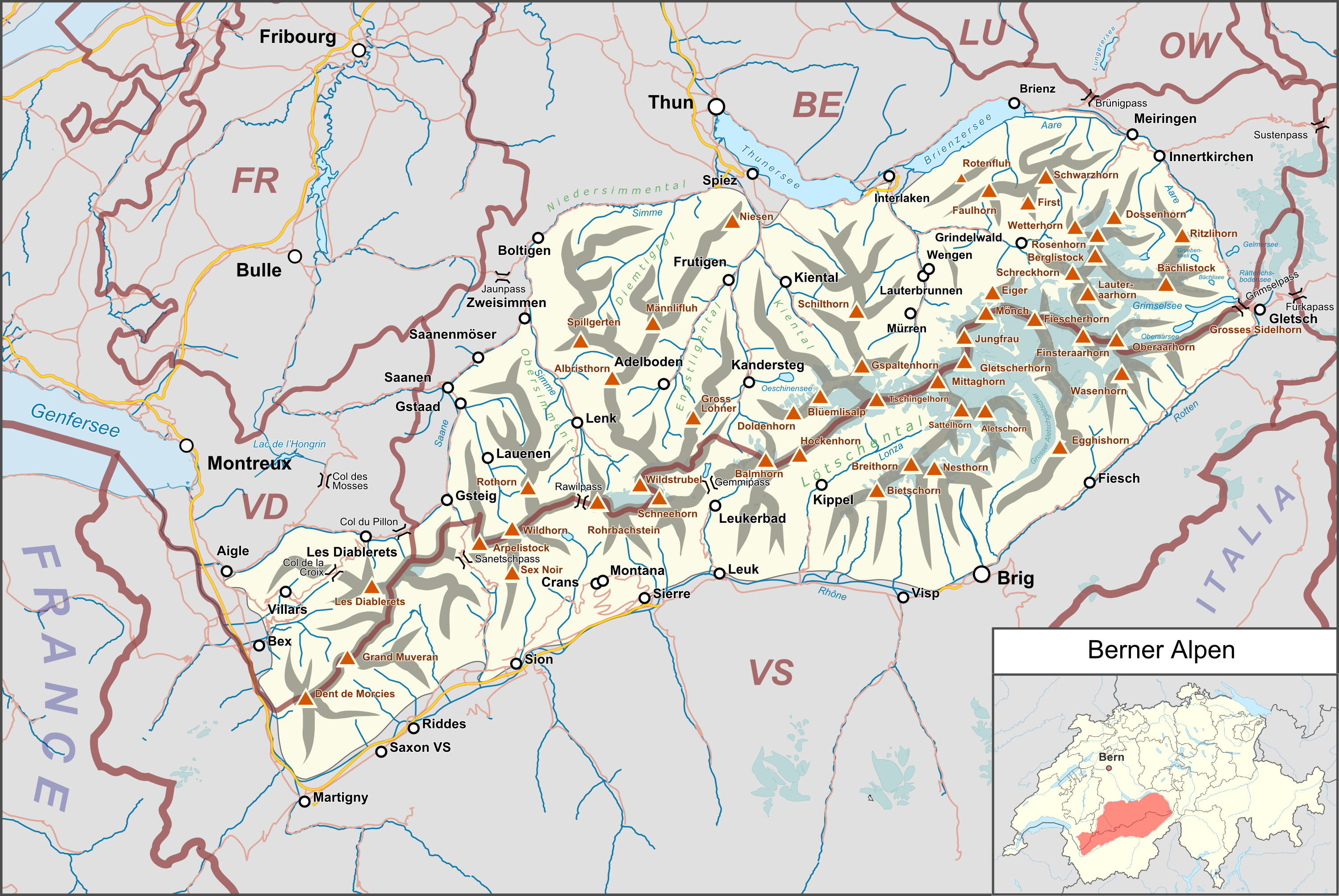
Deutsch: Lagekarte der Berner Alpen. |
|||||||||
| Date | ||||||||||
| Source |
Own work Map was created using:
|
|||||||||
| Creator | ||||||||||
| Permission (Reusing this file) |
Map data (c) OpenStreetMap (and) contributors, CC-BY-SA | |||||||||
| Geotemporal data | ||||||||||
| Bounding box |
|
|||||||||
| Georeferencing | ||||||||||
Licensing
I, the copyright holder of this work, hereby publish it under the following license:
This file is licensed under the Creative Commons Attribution 3.0 Unported license.
- You are free:
- to share – to copy, distribute and transmit the work
- to remix – to adapt the work
- Under the following conditions:
- attribution – You must give appropriate credit, provide a link to the license, and indicate if changes were made. You may do so in any reasonable manner, but not in any way that suggests the licensor endorses you or your use.
| This work is licensed under the Open Database License (summary). |
File history
Click on a date/time to view the file as it appeared at that time.
| Date/Time | Thumbnail | Dimensions | User | Comment | |
|---|---|---|---|---|---|
| current | 16:21, 26 August 2018 | | 2,999 × 2,007 (2.35 MB) | Pechristener | korr Lage Brünigpass |
| 15:00, 22 October 2016 |  | 2,999 × 2,007 (2.35 MB) | Pechristener | Beschriftung erg | |
| 14:21, 9 October 2016 |  | 2,999 × 2,007 (2.31 MB) | Pechristener | Lagekarte nachgebessert | |
| 18:25, 23 August 2016 |  | 2,999 × 2,007 (2.31 MB) | Pechristener | korr Grenzen der Berner Alpen gem Disk | |
| 18:30, 18 August 2016 |  | 2,999 × 2,007 (2.33 MB) | Pechristener | {{Map |Description={{de|1=Lagekarte des de:Berner Alpen}} |Source ={{own}} Map was created using: *[http://www.openstreetmap.org/ Open Street Map] *Switzerland location map.svg for location map |A... |
File usage
The following pages on the English Wikipedia use this file (pages on other projects are not listed):
Global file usage
The following other wikis use this file:
- Usage on arz.wikipedia.org
- Usage on de.wikipedia.org
- Eiger
- Schilthorn
- Männlichen
- Wetterhorn
- Jungfrau (Berg)
- Kleine Scheidegg
- Mönch (Berg)
- Berner Alpen
- Finsteraarhorn
- Jungfraujoch
- Kander (Aare)
- Schwarze Lütschine
- Aletschgletscher
- Lötschberg
- Wildstrubel
- Les Diablerets (Berg)
- Muveran
- Simme
- Langgletscher
- Schwarzhorn (Berner Alpen)
- Faulhorn
- Gemmipass
- Lohner (Berg)
- Märjelensee
- Col de la Croix (Waadt)
- Grosse Scheidegg
- Bachalpsee
- Lauenensee
- Grosses Fiescherhorn
- Daubenhorn
- Eggishorn
- Fiescheralp
- Breithorn (Lauterbrunnen)
- Mittaghorn (Lauterbrunnen)
- Chirel
- Mittellegihütte
- Mönchsjochhütte
- Anenhütte
- Sex Rouge (Les Diablerets)
- Fründenhütte
- Saxetbach
- Bettmerhorn
- Benutzer Diskussion:Pechristener/Archiv/1
- Oberaarjochhütte
- Lauteraarhütte
- Oldenhorn
- Guggihütte
- Benutzer:FkMohr/Baustelle/Test
- Vorlage:Positionskarte Berner Alpen
View more global usage of this file.