
File:Bedford Hall - geograph.org.uk - 1323398.jpg
No higher resolution available.
Bedford_Hall_-_geograph.org.uk_-_1323398.jpg (640 × 426 pixels, file size: 61 KB, MIME type: image/jpeg)
| This is a file from the Wikimedia Commons. Information from its description page there is shown below. Commons is a freely licensed media file repository. You can help. |
Summary
| Description |
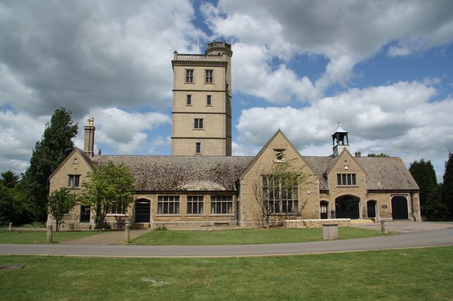
English: Bedford Hall The 7th Duke of Bedford's model agricultural village included a modern water supply and sewerage scheme. This neo-Jacobean building erected in 1855 includes a 96ft high water tower supplying fresh water to the 19th century village and sewerage pumping facilities. Now known as Bedford Hall |
| Date | |
| Source | From geograph.org.uk |
| Author | Richard Croft |
| Attribution (required by the license) | Richard Croft / Bedford Hall / |
| Camera location | | View this and other nearby images on: OpenStreetMap |
|---|
_heading:0.00&language=en)
| Object location | | View this and other nearby images on: OpenStreetMap |
|---|
_heading:0.00&language=en)
Licensing

|
This image was taken from the Geograph project collection. See this photograph's page on the Geograph website for the photographer's contact details. The copyright on this image is owned by Richard Croft and is licensed for reuse under the Creative Commons Attribution-ShareAlike 2.0 license.
|
This file is licensed under the Creative Commons Attribution-Share Alike 2.0 Generic license.
Attribution: Richard Croft
- You are free:
- to share – to copy, distribute and transmit the work
- to remix – to adapt the work
- Under the following conditions:
- attribution – You must give appropriate credit, provide a link to the license, and indicate if changes were made. You may do so in any reasonable manner, but not in any way that suggests the licensor endorses you or your use.
- share alike – If you remix, transform, or build upon the material, you must distribute your contributions under the same or compatible license as the original.
File history
Click on a date/time to view the file as it appeared at that time.
| Date/Time | Thumbnail | Dimensions | User | Comment | |
|---|---|---|---|---|---|
| current | 20:09, 27 February 2011 | | 640 × 426 (61 KB) | GeographBot | == {{int:filedesc}} == {{Information |description={{en|1=Bedford Hall The 7th Duke of Bedford's model agricultural village included a modern water supply and sewerage scheme. This neo-Jacobean building erected in 1855 includes a 96ft high water tower supp |
File usage
The following pages on the English Wikipedia use this file (pages on other projects are not listed):
Global file usage
The following other wikis use this file:
- Usage on arz.wikipedia.org
- Usage on nl.wikipedia.org
- Usage on www.wikidata.org