
File:Bartlett, Nebraska Bartlett Foods mill.JPG

Size of this preview: 800 × 399 pixels. Other resolutions: 320 × 160 pixels | 640 × 319 pixels | 1,024 × 511 pixels | 1,280 × 639 pixels | 2,405 × 1,200 pixels.
Original file (2,405 × 1,200 pixels, file size: 859 KB, MIME type: image/jpeg)
| This is a file from the Wikimedia Commons. Information from its description page there is shown below. Commons is a freely licensed media file repository. You can help. |
Summary
| Description |
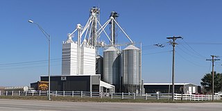
English: Bartlett Foods feed mill, located on U.S. Highway 281/Nebraska Highway 70 at eastern edge of Bartlett, Nebraska. |
| Date | |
| Source | Own work |
| Author | Ammodramus |
| Camera location | | View this and other nearby images on: OpenStreetMap |
|---|
Licensing
| I, the copyright holder of this work, release this work into the public domain. This applies worldwide. In some countries this may not be legally possible; if so: I grant anyone the right to use this work for any purpose, without any conditions, unless such conditions are required by law. |
File history
Click on a date/time to view the file as it appeared at that time.
| Date/Time | Thumbnail | Dimensions | User | Comment | |
|---|---|---|---|---|---|
| current | 19:01, 8 October 2010 | | 2,405 × 1,200 (859 KB) | Ammodramus | {{Information |Description={{en|1=Bartlett Foods feed mill, located on {{w|U.S. Highway 281}}/{{w|Nebraska Highway 70}} at eastern edge of {{w|Bartlett, Nebraska}}.}} |Source={{own}} |Author=Ammodramus |Date=2010-10-04 |Permission= |ot |
File usage
The following pages on the English Wikipedia use this file (pages on other projects are not listed):
Global file usage
The following other wikis use this file:
- Usage on ar.wikipedia.org
- Usage on azb.wikipedia.org
- Usage on ca.wikipedia.org
- Usage on ceb.wikipedia.org
- Usage on es.wikipedia.org
- Usage on eu.wikipedia.org
- Usage on fa.wikipedia.org
- Usage on fr.wikipedia.org
- Usage on ht.wikipedia.org
- Usage on it.wikipedia.org
- Usage on ky.wikipedia.org
- Usage on lld.wikipedia.org
- Usage on pl.wikipedia.org
- Usage on pt.wikipedia.org
- Usage on sr.wikipedia.org
- Usage on uk.wikipedia.org
- Usage on www.wikidata.org
- Usage on zh-min-nan.wikipedia.org
- Usage on zh.wikipedia.org