
File:Barking Barrier - geograph.org.uk - 321573.jpg
No higher resolution available.
Barking_Barrier_-_geograph.org.uk_-_321573.jpg (640 × 480 pixels, file size: 81 KB, MIME type: image/jpeg)
| This is a file from the Wikimedia Commons. Information from its description page there is shown below. Commons is a freely licensed media file repository. You can help. |
Summary
| Description |
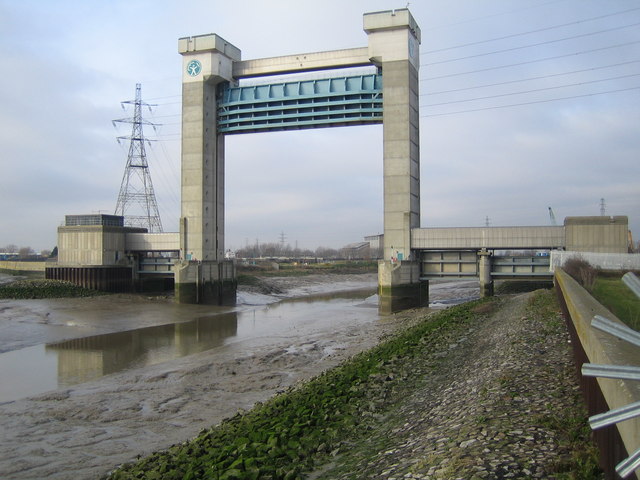
English: Barking Barrier This is the downstream side of the barrier, which was built over a period of four years, being completed in 1983. It is about 60 metres high, and was needed to be this size to allow shipping to reach the Town Quay in Barking further upstream. The barrier crosses the Barking Creek reach of the River Roding, at its confluence with the River Thames. |
| Date | |
| Source | From geograph.org.uk |
| Author | Nigel Cox |
| Attribution (required by the license) | Nigel Cox / Barking Barrier / |
| Camera location | | View this and other nearby images on: OpenStreetMap |
|---|
_heading:315.00&language=en)
| Object location | | View this and other nearby images on: OpenStreetMap |
|---|
_heading:315.00&language=en)
Licensing

|
This image was taken from the Geograph project collection. See this photograph's page on the Geograph website for the photographer's contact details. The copyright on this image is owned by Nigel Cox and is licensed for reuse under the Creative Commons Attribution-ShareAlike 2.0 license.
|
This file is licensed under the Creative Commons Attribution-Share Alike 2.0 Generic license.
Attribution: Nigel Cox
- You are free:
- to share – to copy, distribute and transmit the work
- to remix – to adapt the work
- Under the following conditions:
- attribution – You must give appropriate credit, provide a link to the license, and indicate if changes were made. You may do so in any reasonable manner, but not in any way that suggests the licensor endorses you or your use.
- share alike – If you remix, transform, or build upon the material, you must distribute your contributions under the same or compatible license as the original.
File history
Click on a date/time to view the file as it appeared at that time.
| Date/Time | Thumbnail | Dimensions | User | Comment | |
|---|---|---|---|---|---|
| current | 18:13, 30 December 2010 | | 640 × 480 (81 KB) | GeographBot | == {{int:filedesc}} == {{Information |description={{en|1=Barking Barrier This is the downstream side of the barrier, which was built over a period of four years, being completed in 1983. It is about 60 metres high, and was needed to be this size to allow |
File usage
The following pages on the English Wikipedia use this file (pages on other projects are not listed):
Global file usage
The following other wikis use this file:
- Usage on www.wikidata.org