
File:Balaklava bay.jpg

Size of this preview: 800 × 197 pixels. Other resolutions: 320 × 79 pixels | 640 × 158 pixels | 1,024 × 252 pixels | 1,280 × 315 pixels | 2,560 × 630 pixels | 10,212 × 2,514 pixels.
Original file (10,212 × 2,514 pixels, file size: 15.53 MB, MIME type: image/jpeg)
| This is a file from the Wikimedia Commons. Information from its description page there is shown below. Commons is a freely licensed media file repository. You can help. |
Summary
| Description |
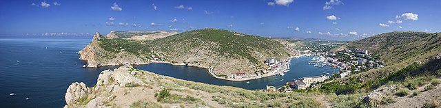
Українська: Панорамний вид на Балаклавську бухту. За часів Радянського Союзу тут була база підводних човнів, сьогодні відкрита як музей. Крим, Україна.
English: Panoramic view of Balaklava Bay, in time of Soviet Union this was submarine base, today opened as museum. Crimea, Ukraine (with referendum Crimea passed to Russia in 2014, disputed by Ukraine.) Français : Vue panoramique de la baie de Balaklava. Base sous-marine au temps de l'Union Soviétique, le site est désormais un musée. Crimée, Ukraine. Italiano: Vista panoramica della baia di Balaklava. Русский: Балаклавская бухта, Крым, Украина. Српски / srpski: Заљев Балаклава, за време Совјетског савеза подморничка база. Крим, Украјина. Slovenščina: Zaliv Balaklava na polotoku Krim, Ukrajina. V sovjetskih časih je služil kot podmorniški zaliv, danes muzej. |
| Date | |
| Source | Own work |
| Author | Petar Milošević |
| Permission (Reusing this file) |
Petar Milošević (author) |
| Other versions | Derivative works of this file: Balaklava bay banner.jpg |
| Camera location | | View this and other nearby images on: OpenStreetMap |
|---|
Assessment
|

|
This image has been assessed under the valued image criteria and is considered the most valued image on Commons within the scope: Balaklava Bay, a view to North, Crimea. You can see its nomination here. |
This image was selected as picture of the day on Wikimedia Commons for 28 July 2013. It was captioned as follows: English: Panoramic view of Balaklava Bay, in time of Soviet Union this was a submarine base, today opened as museum. Crimea, Ukraine. Other languages:
English: Panoramic view of Balaklava Bay, in time of Soviet Union this was a submarine base, today opened as museum. Crimea, Ukraine. Italiano: Vista panoramica della baia di Balaklava, sede di una base per sottomarini all'epoca dell'Unione Sovietica e ora trasformata in un museo sulla guerra di Crimea. Crimea, Ucraina. Magyar: A Balaklavai-öböl a Krímben. A szovjet időszakban tengeralattjáró-bázis volt ott, amely napjainkban haditengerészeti múzeumként működik. Nederlands: Panoramisch zicht op de baai van Balaklava op Krim in Oekraïne. Ten tijde van de Sovjet-Unie bevond zich hier een geheime basis voor onderzeeërs, dat tegenwoordig bezocht kan worden als museum. Українська: Панорамний вид на Балаклавську бухту. За часів Радянського Союзу тут була база підводних човнів, сьогодні відкрита як музей. Крим, Україна. 中文: 乌克兰克里米亚巴拉克拉瓦湾,在苏联时期是一个海军基地,如今是博物馆。 |
Licensing
I, the copyright holder of this work, hereby publish it under the following license:
This file is licensed under the Creative Commons Attribution-Share Alike 4.0 International license.
- You are free:
- to share – to copy, distribute and transmit the work
- to remix – to adapt the work
- Under the following conditions:
- attribution – You must give appropriate credit, provide a link to the license, and indicate if changes were made. You may do so in any reasonable manner, but not in any way that suggests the licensor endorses you or your use.
- share alike – If you remix, transform, or build upon the material, you must distribute your contributions under the same or compatible license as the original.
File history
Click on a date/time to view the file as it appeared at that time.
| Date/Time | Thumbnail | Dimensions | User | Comment | |
|---|---|---|---|---|---|
| current | 16:40, 13 June 2013 | 10,212 × 2,514 (15.53 MB) | PetarM | border correction | |
| 16:18, 13 June 2013 | 10,212 × 2,514 (15.53 MB) | PetarM | User created page with UploadWizard |
File usage
The following pages on the English Wikipedia use this file (pages on other projects are not listed):
Global file usage
The following other wikis use this file:
- Usage on af.wikipedia.org
- Usage on be-tarask.wikipedia.org
- Usage on be.wikipedia.org
- Usage on bn.wikipedia.org
- Usage on crh.wikipedia.org
- Usage on cv.wikipedia.org
- Usage on el.wikipedia.org
- Usage on fa.wikipedia.org
- Usage on fi.wikipedia.org
- Usage on fr.wikipedia.org
- Usage on hu.wikipedia.org
- Usage on hy.wikipedia.org
- Usage on it.wikipedia.org
- Usage on ka.wikipedia.org
- Usage on ko.wikipedia.org
- Usage on krc.wikipedia.org
- Usage on lbe.wikipedia.org
- Usage on nl.wikipedia.org
- Usage on os.wikipedia.org
- Usage on pt.wikipedia.org
- Usage on ro.wikipedia.org
- Usage on ru.wikipedia.org
- Usage on ru.wikinews.org
- Usage on sah.wikipedia.org
- Usage on sl.wikipedia.org
- Usage on sr.wikipedia.org
- Usage on tr.wikipedia.org
- Usage on uk.wikipedia.org
- Usage on uk.wikivoyage.org
- Usage on vi.wikipedia.org
- Usage on www.wikidata.org
- Usage on xal.wikipedia.org
- Usage on zh.wikipedia.org