
File:Bala Mill Falls - geograph.org.uk - 1231649.jpg
No higher resolution available.
Bala_Mill_Falls_-_geograph.org.uk_-_1231649.jpg (640 × 512 pixels, file size: 100 KB, MIME type: image/jpeg)
| This is a file from the Wikimedia Commons. Information from its description page there is shown below. Commons is a freely licensed media file repository. You can help. |
Summary
| Description |
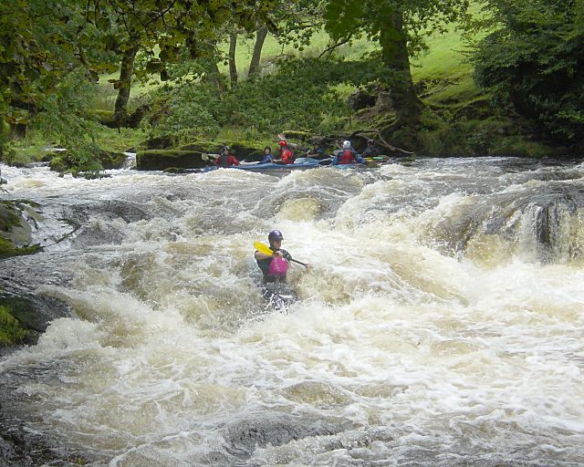
English: Bala Mill Falls The Lower Tryweryn runs from the whitewater centre down to the main road bridge in Bala village and is mostly grade 2 to 3. Since the river is dam-released, it is often possible when other rivers have no water, and you can phone in advance to check the release level (if any). Under the Welsh Canoeing Association's new access policy, there is no longer any charge for using the river. The one hard rapid, Bala Mill Falls, usually given grade 4, is towards the end of the run, and is often portaged river right where a permissive path runs next to the leat. This photo was taken from the end of the portage (when I was new enough to kayaking to choose not to run the falls). The usual approach is to break out river left above the falls, from where you can get an idea of the line, but breaking in and choosing the right spot is the most difficult part. The paddler shown has got the right line and is just blasting through the bottom stopper. Offline, the first stopper or a hidden rock may slow the boat down, then this bottom stopper has a tendency to backloop boats, especially shorter playboats. Below the aerated pool, there is a relatively calm pool in which to collect swimmers and equipment. |
| Date | |
| Source | From geograph.org.uk |
| Author | Andy Waddington |
| Attribution (required by the license) | Andy Waddington / Bala Mill Falls / |
| Camera location | | View this and other nearby images on: OpenStreetMap |
|---|
_heading:337.00&language=en)
| Object location | | View this and other nearby images on: OpenStreetMap |
|---|
_heading:337.00&language=en)
Licensing

|
This image was taken from the Geograph project collection. See this photograph's page on the Geograph website for the photographer's contact details. The copyright on this image is owned by Andy Waddington and is licensed for reuse under the Creative Commons Attribution-ShareAlike 2.0 license.
|
This file is licensed under the Creative Commons Attribution-Share Alike 2.0 Generic license.
Attribution: Andy Waddington
- You are free:
- to share – to copy, distribute and transmit the work
- to remix – to adapt the work
- Under the following conditions:
- attribution – You must give appropriate credit, provide a link to the license, and indicate if changes were made. You may do so in any reasonable manner, but not in any way that suggests the licensor endorses you or your use.
- share alike – If you remix, transform, or build upon the material, you must distribute your contributions under the same or compatible license as the original.
File history
Click on a date/time to view the file as it appeared at that time.
| Date/Time | Thumbnail | Dimensions | User | Comment | |
|---|---|---|---|---|---|
| current | 12:32, 26 February 2011 | | 640 × 512 (100 KB) | GeographBot | == {{int:filedesc}} == {{Information |description={{en|1=Bala Mill Falls The Lower Tryweryn runs from the whitewater centre down to the main road bridge in Bala village and is mostly grade 2 to 3. Since the river is dam-released, it is often possible when |
File usage
The following pages on the English Wikipedia use this file (pages on other projects are not listed):