
File:Babuyan islands en.png

Size of this preview: 800 × 485 pixels. Other resolutions: 320 × 194 pixels | 640 × 388 pixels | 1,205 × 731 pixels.
Original file (1,205 × 731 pixels, file size: 346 KB, MIME type: image/png)
| This is a file from the Wikimedia Commons. Information from its description page there is shown below. Commons is a freely licensed media file repository. You can help. |
Summary
| Description |
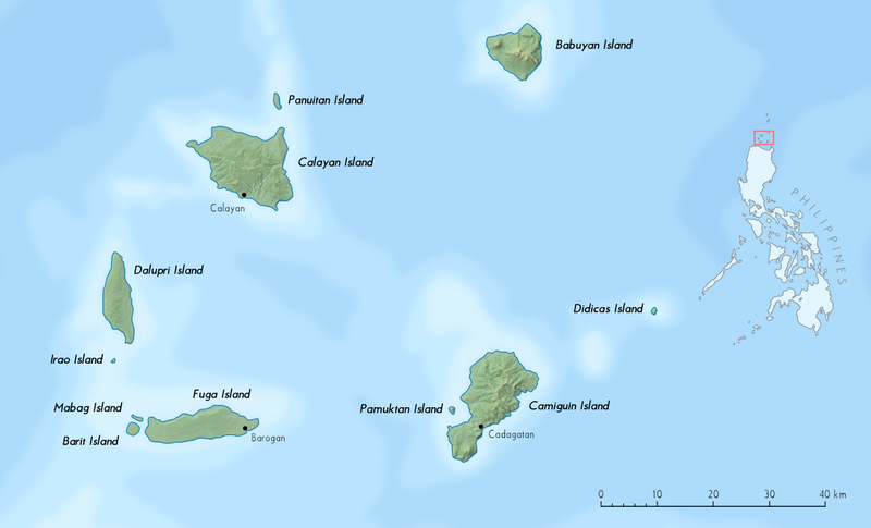
Deutsch: Babuyan-Inseln, philippinische Inselgruppe in der Luzonstraße, nördlich von Luzon. Verwendete Kartendaten: NASA Shuttle Radar Topography Mission digital topographic data (SRTM3 2.1) (Public Domain) English: Babuyan Islands, archipelago located in the Luzon Strait north of Luzon island in the Philippines. Used map data: NASA Shuttle Radar Topography Mission digital topographic data (SRTM3 2.1) (Public Domain) |
| Date | |
| Source | Own work |
| Author | Alexander Altenhof (KaterBegemot) |
Licensing
I, the copyright holder of this work, hereby publish it under the following licenses:

|
Permission is granted to copy, distribute and/or modify this document under the terms of the GNU Free Documentation License, Version 1.2 or any later version published by the Free Software Foundation; with no Invariant Sections, no Front-Cover Texts, and no Back-Cover Texts. A copy of the license is included in the section entitled GNU Free Documentation License. |
This file is licensed under the Creative Commons Attribution 3.0 Unported license.
- You are free:
- to share – to copy, distribute and transmit the work
- to remix – to adapt the work
- Under the following conditions:
- attribution – You must give appropriate credit, provide a link to the license, and indicate if changes were made. You may do so in any reasonable manner, but not in any way that suggests the licensor endorses you or your use.
You may select the license of your choice.
File history
Click on a date/time to view the file as it appeared at that time.
| Date/Time | Thumbnail | Dimensions | User | Comment | |
|---|---|---|---|---|---|
| current | 15:53, 18 July 2012 | | 1,205 × 731 (346 KB) | KaterBegemot | {{Information |Description= {{de|1=Babuyan-Inseln, philippinische Inselgruppe in der Luzonstraße, nördlich von Luzon. Verwendete Kartendaten: [http://dds.cr.usgs.gov/srtm/version2_1/SRTM3/ NASA Shuttle Radar Topography Mission digital topographic da... |
File usage
The following pages on the English Wikipedia use this file (pages on other projects are not listed):
Global file usage
The following other wikis use this file:
- Usage on arz.wikipedia.org
- Usage on az.wikipedia.org
- Usage on bjn.wikipedia.org
- Usage on bn.wikipedia.org
- Usage on ca.wikipedia.org
- Usage on ceb.wikipedia.org
- Usage on de.wikipedia.org
- Usage on el.wikipedia.org
- Usage on eo.wikipedia.org
- Usage on es.wikipedia.org
- Usage on eu.wikipedia.org
- Usage on fa.wikipedia.org
- Usage on fi.wikipedia.org
- Usage on fr.wikipedia.org
- Usage on id.wikipedia.org
- Usage on ilo.wikipedia.org
- Usage on it.wikipedia.org
- Usage on ja.wikipedia.org
View more global usage of this file.