
File:Authorized Plan of Protection.jpg

Size of this preview: 800 × 506 pixels. Other resolutions: 320 × 203 pixels | 640 × 405 pixels | 1,024 × 648 pixels | 1,280 × 810 pixels | 2,436 × 1,542 pixels.
Original file (2,436 × 1,542 pixels, file size: 2.31 MB, MIME type: image/jpeg)
| This is a file from the Wikimedia Commons. Information from its description page there is shown below. Commons is a freely licensed media file repository. You can help. |
Summary
| Description |
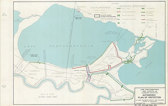
English: Authorized Plan of Protection for Lake Pontchartrain and Vicinity, Louisiana, November 1965. Map by U.S. Army Engineer District, New Orleans Corps of Engineers. Revised Dec 1970 and April 1978.
Source: A 1980 design memorandum for the Florida Avenue Floodwall and floodgate complex at the IHNC. |
| Date | |
| Source |
Authorized Plan of Protection for Lake Pontchartrain and Vicinity, Louisiana, November 1965. Map by U.S. Army Engineer District, New Orleans Corps of Engineers. Revised Dec 1970 and April 1978. A 1980 design memorandum for the Florida Avenue Floodwall and floodgate complex at the IHNC. |
| Author | U S Army Corps of Engineers |
Licensing
This image or file is a work of a U.S. Army Corps of Engineers soldier or employee, taken or made as part of that person's official duties. As a work of the U.S. federal government, the image is in the public domain.
|
File history
Click on a date/time to view the file as it appeared at that time.
| Date/Time | Thumbnail | Dimensions | User | Comment | |
|---|---|---|---|---|---|
| current | 23:07, 28 November 2023 | | 2,436 × 1,542 (2.31 MB) | Camellia NOLA | Uploaded while editing "2005 levee failures in Greater New Orleans" on en.wikipedia.org |
File usage
The following pages on the English Wikipedia use this file (pages on other projects are not listed):