
File:Archäologischer Park Xanten DE.png

Size of this preview: 691 × 599 pixels. Other resolutions: 277 × 240 pixels | 553 × 480 pixels | 886 × 768 pixels | 1,181 × 1,024 pixels | 1,960 × 1,700 pixels.
Original file (1,960 × 1,700 pixels, file size: 625 KB, MIME type: image/png)
| This is a file from the Wikimedia Commons. Information from its description page there is shown below. Commons is a freely licensed media file repository. You can help. |
Summary
| Description |
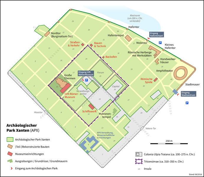
Deutsch: Karte des Archäologischen Parks Xanten
English: Map of the Archaeological Park Xanten |
|||
| Date | ||||
| Source |
Own work
|
|||
| Author | Thoroe | |||
| Permission (Reusing this file) |
|
| Camera location | | View this and other nearby images on: OpenStreetMap |
|---|
| Object location | | View this and other nearby images on: OpenStreetMap |
|---|

|
This map has been made or improved in the German Kartenwerkstatt (Map Lab). You can propose maps to improve as well.
|
Licensing
This file is licensed under the Creative Commons Attribution-Share Alike 3.0 Unported license.
Attribution: Thomas Römer/OpenStreetMap data
- You are free:
- to share – to copy, distribute and transmit the work
- to remix – to adapt the work
- Under the following conditions:
- attribution – You must give appropriate credit, provide a link to the license, and indicate if changes were made. You may do so in any reasonable manner, but not in any way that suggests the licensor endorses you or your use.
- share alike – If you remix, transform, or build upon the material, you must distribute your contributions under the same or compatible license as the original.
File history
Click on a date/time to view the file as it appeared at that time.
| Date/Time | Thumbnail | Dimensions | User | Comment | |
|---|---|---|---|---|---|
| current | 14:58, 4 September 2018 | | 1,960 × 1,700 (625 KB) | Thoroe | + neues Stück Stadtmauer |
| 10:56, 3 September 2018 |  | 1,960 × 1,700 (624 KB) | Thoroe | Update | |
| 14:59, 9 October 2012 |  | 980 × 850 (255 KB) | Thoroe | Tricensimae detaillierter und eindeutiger | |
| 20:57, 8 October 2012 |  | 980 × 850 (250 KB) | Thoroe | Erweiterte Darstellung | |
| 19:46, 6 October 2012 |  | 980 × 850 (236 KB) | Thoroe | {{Information |Description ={{de|1=Karte des Archäologischen Parks Xanten}} |Source ={{own}} *[http://www.apx.de/archaeologischerpark/apx_wegweiser.pdf] *[http://www.apx.de/archaeologischerpark/illu... |
File usage
The following pages on the English Wikipedia use this file (pages on other projects are not listed):
Global file usage
The following other wikis use this file:
- Usage on ca.wikipedia.org
- Usage on de.wikipedia.org
- LVR-Archäologischer Park Xanten
- Tricensimae
- Colonia Ulpia Traiana
- Wikipedia:Redaktion Altertum/Römischer Limes/Pictothek/Niedergermanischer Limes (Deutschland)
- Benutzer:Thoroe
- Liste der Insulae und Bauten in der Colonia Ulpia Traiana
- Benutzer:Patrick Stützel
- Wikipedia:Kartenwerkstatt/Archiv/2012-10
- Wikipedia:Kartenwerkstatt/Karte des Tages/Galerie
- Kapitol der Colonia Ulpia Traiana
- Amphitheater der Colonia Ulpia Traiana
- LVR-RömerMuseum Xanten
- Usage on es.wikipedia.org
- Usage on it.wikipedia.org
- Usage on ko.wikipedia.org
- Usage on nl.wikipedia.org
- Usage on pt.wikipedia.org
- Usage on www.wikidata.org