
File:Annapolis and Elk Ridge Railroad on 1895 map.jpg
No higher resolution available.
Annapolis_and_Elk_Ridge_Railroad_on_1895_map.jpg (287 × 218 pixels, file size: 48 KB, MIME type: image/jpeg)
| This is a file from the Wikimedia Commons. Information from its description page there is shown below. Commons is a freely licensed media file repository. You can help. |
Summary
| Description |
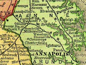
English: Cropped 1895 map of Maryland in 1895 (Color Landform Atlas/Ray Sterner) |
| Date | |
| Source | Johns Hopkins University Applied Physics Laboratory |
| Author | Unknown author |
Licensing
This image is in the public domain because it is a mere mechanical scan or photocopy of a public domain original, or – from the available evidence – is so similar to such a scan or photocopy that no copyright protection can be expected to arise. The original itself is in the public domain for the following reason:
This tag is designed for use where there may be a need to assert that any enhancements (eg brightness, contrast, colour-matching, sharpening) are in themselves insufficiently creative to generate a new copyright. It can be used where it is unknown whether any enhancements have been made, as well as when the enhancements are clear but insufficient. For known raw unenhanced scans you can use an appropriate {{PD-old}} tag instead. For usage, see Commons:When to use the PD-scan tag.  |
Original upload log
The original description page was here. All following user names refer to en.wikipedia.
| Date/Time | Dimensions | User | Comment |
|---|---|---|---|
| 2007-05-03 02:09 | 287×218× (49562 bytes) | Volcycle | cropped image of map of Maryland in 1895 (Color Landform Atlas/Ray Sterner) http://fermi.jhuapl.edu/states/1895/md_1895.jpg This map was published before 1923 |
File history
Click on a date/time to view the file as it appeared at that time.
| Date/Time | Thumbnail | Dimensions | User | Comment | |
|---|---|---|---|---|---|
| current | 01:08, 3 July 2016 | | 287 × 218 (48 KB) | Pi1415926535 | Transferred from en.wikipedia |
File usage
The following pages on the English Wikipedia use this file (pages on other projects are not listed):
Global file usage
The following other wikis use this file:
- Usage on www.wikidata.org