
File:Aegadian Islands map.png
No higher resolution available.
Aegadian_Islands_map.png (690 × 528 pixels, file size: 112 KB, MIME type: image/png)
| This is a file from the Wikimedia Commons. Information from its description page there is shown below. Commons is a freely licensed media file repository. You can help. |
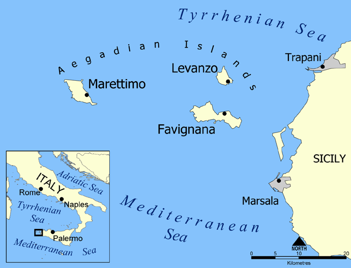
Map of the Aegadian Islands showing the islands of Favignana, Levanzo, and Marettimo, and the nearby port cities of Trapani and Marsala, Sicily.
Blank version available at Image:Aegadian Islands blank map.png.
Created by NormanEinstein, May 19, 2005.
| I, the copyright holder of this work, release this work into the public domain. This applies worldwide. In some countries this may not be legally possible; if so: I grant anyone the right to use this work for any purpose, without any conditions, unless such conditions are required by law. |
File history
Click on a date/time to view the file as it appeared at that time.
| Date/Time | Thumbnail | Dimensions | User | Comment | |
|---|---|---|---|---|---|
| current | 22:24, 26 February 2016 | | 690 × 528 (112 KB) | Ras67 | black frame removed, opt. |
| 13:58, 19 May 2005 |  | 700 × 538 (150 KB) | NormanEinstein | Map of the Aegadian Islands showing the islands of Favignana, Levanzo, and Marettimo, and the nearby port cities of Trapani and Marsala, Sicily. Created by NormanEinstein, May 19, 2005. {{PD-self}} |
File usage
The following pages on the English Wikipedia use this file (pages on other projects are not listed):
Global file usage
The following other wikis use this file:
- Usage on ar.wikipedia.org
- Usage on be.wikipedia.org
- Usage on bg.wikipedia.org
- Usage on bs.wikipedia.org
- Usage on ca.wikipedia.org
- Usage on cs.wikipedia.org
- Usage on da.wikipedia.org
- Usage on de.wikipedia.org
- Usage on el.wikipedia.org
- Usage on en.wiktionary.org
- Usage on eo.wikipedia.org
- Usage on fa.wikipedia.org
- Usage on fi.wikipedia.org
- Usage on fr.wikipedia.org
- Usage on fr.wiktionary.org
- Usage on fy.wikipedia.org
- Usage on gl.wikipedia.org
- Usage on he.wikipedia.org
- Usage on id.wikipedia.org
- Usage on it.wikipedia.org
- Usage on ja.wikipedia.org
- Usage on ka.wikipedia.org
View more global usage of this file.