
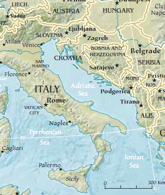
File:Adriatic Sea Geographic Map.jpg
No higher resolution available.
Adriatic_Sea_Geographic_Map.jpg (337 × 399 pixels, file size: 129 KB, MIME type: image/jpeg)
| This is a file from the Wikimedia Commons. Information from its description page there is shown below. Commons is a freely licensed media file repository. You can help. |
Summary
| Description |
English: Geographic map of Adriatic Sea and surrounding territories |
| Date | |
| Source | https://www.cia.gov/library/publications/the-world-factbook/graphics/ref_maps/pdf/europe.pdf |
| Author | w:Central Intelligence Agency |
Scale 1:19,300,000 Lambert Conformal Conic Projection, standard parallels 40ºN and 68ºN
Licensing
| This image is a work of a Central Intelligence Agency employee, taken or made as part of that person's official duties. As a Work of the United States Government, this image or media is in the public domain in the United States.
|

|
File history
Click on a date/time to view the file as it appeared at that time.
| Date/Time | Thumbnail | Dimensions | User | Comment | |
|---|---|---|---|---|---|
| current | 20:42, 13 May 2012 | | 337 × 399 (129 KB) | Tomobe03 | Scale ruler (300km), 40N parallel, 20E meridian markings |
| 20:35, 13 May 2012 |  | 337 × 399 (127 KB) | Tomobe03 |
File usage
No pages on the English Wikipedia use this file (pages on other projects are not listed).
Global file usage
The following other wikis use this file:
- Usage on uk.wikipedia.org