
File:Abbey & West Dereham station (remains) geograph-3221892-by-Ben-Brooksbank.jpg

Size of this preview: 800 × 497 pixels. Other resolutions: 320 × 199 pixels | 640 × 398 pixels | 1,024 × 637 pixels | 1,280 × 796 pixels | 2,231 × 1,387 pixels.
Original file (2,231 × 1,387 pixels, file size: 2.63 MB, MIME type: image/jpeg)
| This is a file from the Wikimedia Commons. Information from its description page there is shown below. Commons is a freely licensed media file repository. You can help. |
_geograph-3221892-by-Ben-Brooksbank.jpg)
Summary
| Description |
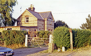
English: Abbey & West Dereham station (remains). View eastward, towards Stoke Ferry: ex-GER Denver - Stoke Ferry branch. The station and branch lost their passenger service from 22/9/30, but goods continued on the branch until 19/4/65 - to Abbey until 31/1/6 |
| Date | |
| Source | From geograph.org.uk |
| Author | Ben Brooksbank |
| Permission (Reusing this file) |
Creative Commons Attribution Share-alike license 2.0 |
| Attribution (required by the license) | Ben Brooksbank / Abbey & West Dereham station (remains) / |
| Camera location | | View this and other nearby images on: OpenStreetMap |
|---|
_geograph-3221892-by-Ben-Brooksbank.jpg¶ms=052.570374_N_0000.441638_E_globe:Earth_type:camera_heading:90.00&language=en)
Licensing

|
This image was taken from the Geograph project collection. See this photograph's page on the Geograph website for the photographer's contact details. The copyright on this image is owned by Ben Brooksbank and is licensed for reuse under the Creative Commons Attribution-ShareAlike 2.0 license.
|
This file is licensed under the Creative Commons Attribution-Share Alike 2.0 Generic license.
Attribution: Ben Brooksbank
- You are free:
- to share – to copy, distribute and transmit the work
- to remix – to adapt the work
- Under the following conditions:
- attribution – You must give appropriate credit, provide a link to the license, and indicate if changes were made. You may do so in any reasonable manner, but not in any way that suggests the licensor endorses you or your use.
- share alike – If you remix, transform, or build upon the material, you must distribute your contributions under the same or compatible license as the original.
File history
Click on a date/time to view the file as it appeared at that time.
| Date/Time | Thumbnail | Dimensions | User | Comment | |
|---|---|---|---|---|---|
| current | 21:31, 23 November 2012 | | 2,231 × 1,387 (2.63 MB) | Chevin | == {{int:filedesc}} == {{Information |Description={{en|1='''Abbey & West Dereham station (remains).'''<br/> View eastward, towards Stoke Ferry: ex-GER Denver - Stoke Ferry branch. The station and branch lost their passenger service from 22/9/30, but go... |
File usage
The following pages on the English Wikipedia use this file (pages on other projects are not listed):
Global file usage
The following other wikis use this file:
- Usage on www.wikidata.org
_geograph-3221892-by-Ben-Brooksbank.jpg)