
File:Aa oldgatwick airport00.jpg
Original file (1,530 × 760 pixels, file size: 475 KB, MIME type: image/jpeg)
| This is a file from the Wikimedia Commons. Information from its description page there is shown below. Commons is a freely licensed media file repository. You can help. |
Summary
| Description |
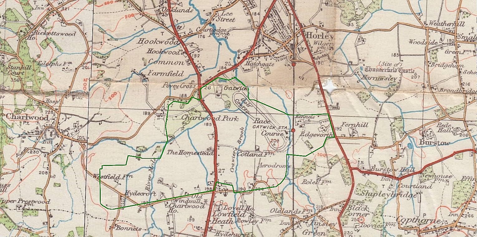
English: Map of the local area later superimposed with the outline of Gatwick Airport boundary, in green. The map without this addition dates to between the 1920s and 1950s.
Author: Chris Cogdon
Based on a CC-BY-SA-2.5 licensed image from the Commons: http://upload.wikimedia.org/wikipedia/commons/8/86/Aa_oldgatwick_00.jpg
The green outline was created by superimposing a map from Google Maps and tracing the indicated airport boundary. The part of the airport east of the railway has become mostly car parking.
Link to Google Earth view of the same area now
The original Gatwick Manor is by the northwest end of the racecourse/golf course marked; partly blurred by the map's old crease. Comparing old and new maps indicates that the modern Gatwick Manor hotel is not the Gatwick Manor shown at the time but a rename for another old building, near Lowfield Heath. |
| Date | |
| Source | Own work |
| Author | Ch'marr (talk) (Uploads) |
Licensing
- You are free:
- to share – to copy, distribute and transmit the work
- to remix – to adapt the work
- Under the following conditions:
- attribution – You must give appropriate credit, provide a link to the license, and indicate if changes were made. You may do so in any reasonable manner, but not in any way that suggests the licensor endorses you or your use.
- share alike – If you remix, transform, or build upon the material, you must distribute your contributions under the same or compatible license as the original.
Original upload log
| Date/Time | Dimensions | User | Comment |
|---|---|---|---|
| 2013-12-04 08:55 | 1530×760× (486017 bytes) | Anthony Appleyard | Sharpen in [[Paintshop pro]]. Repair some image damage (using Windows Paint) where the original paper map was damaged where it had been eroded over an old crease. |
| 2011-11-16 18:11 | 1530×760× (473903 bytes) | Ch'marr | Old Gatwick region with outline of the current Gatwick Airport boundary in green. Author: Chris Cogdon Based on a CC-licenced CC-BY-SA-2.5 image from the Commons: http://upload.wikimedia.org/wikipedia/commons/8/86/Aa_oldgatwick_00.jpg |
File history
Click on a date/time to view the file as it appeared at that time.
| Date/Time | Thumbnail | Dimensions | User | Comment | |
|---|---|---|---|---|---|
| current | 17:30, 28 August 2014 | | 1,530 × 760 (475 KB) | BD2412 | Transferred from en.wikipedia |