
File:A train has arrived at Worstead Station - geograph.org.uk - 1047310.jpg
No higher resolution available.
A_train_has_arrived_at_Worstead_Station_-_geograph.org.uk_-_1047310.jpg (640 × 480 pixels, file size: 112 KB, MIME type: image/jpeg)
| This is a file from the Wikimedia Commons. Information from its description page there is shown below. Commons is a freely licensed media file repository. You can help. |
Summary
| Description |
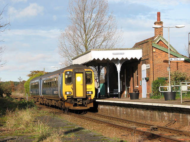
English: A train has arrived at Worstead Station The line connecting the city of Norwich with North Walsham was opened in 1874 and it reached the seaside town of Cromer by 1877. The rest of the line, between Cromer and Sheringham, opened in 1887. It is the remains of the Midland and Great Northern Joint Railway line (based in Melton Constable), part of which is preserved as a heritage railway, between the coastal town of Sheringham and Holt, further inland. Passenger services are operated by 'One Railway' which is part of the National Rail network, operated by National Express East Anglia and uses Class 150, Class 153, Class 156 or Class 170 diesel multiple units. The line is named after the Bittern (a member of the Heron family), a rare bird which can still be found in Norfolk's wetlands. |
| Date | |
| Source | From geograph.org.uk |
| Author | Evelyn Simak |
| Attribution (required by the license) | Evelyn Simak / A train has arrived at Worstead Station / |
| Camera location | | View this and other nearby images on: OpenStreetMap |
|---|
_heading:22.00&language=en)
| Object location | | View this and other nearby images on: OpenStreetMap |
|---|
_heading:22.00&language=en)
Licensing

|
This image was taken from the Geograph project collection. See this photograph's page on the Geograph website for the photographer's contact details. The copyright on this image is owned by Evelyn Simak and is licensed for reuse under the Creative Commons Attribution-ShareAlike 2.0 license.
|
This file is licensed under the Creative Commons Attribution-Share Alike 2.0 Generic license.
Attribution: Evelyn Simak
- You are free:
- to share – to copy, distribute and transmit the work
- to remix – to adapt the work
- Under the following conditions:
- attribution – You must give appropriate credit, provide a link to the license, and indicate if changes were made. You may do so in any reasonable manner, but not in any way that suggests the licensor endorses you or your use.
- share alike – If you remix, transform, or build upon the material, you must distribute your contributions under the same or compatible license as the original.
File history
Click on a date/time to view the file as it appeared at that time.
| Date/Time | Thumbnail | Dimensions | User | Comment | |
|---|---|---|---|---|---|
| current | 20:31, 23 February 2011 | | 640 × 480 (112 KB) | GeographBot | == {{int:filedesc}} == {{Information |description={{en|1=A train has arrived at Worstead Station The line connecting the city of Norwich with North Walsham was opened in 1874 and it reached the seaside town of Cromer by 1877. The rest of the line, between |
File usage
The following pages on the English Wikipedia use this file (pages on other projects are not listed):
Global file usage
The following other wikis use this file:
- Usage on www.wikidata.org