
File:A38 UK road map.svg

Size of this PNG preview of this SVG file: 494 × 600 pixels. Other resolutions: 198 × 240 pixels | 395 × 480 pixels | 633 × 768 pixels | 843 × 1,024 pixels | 1,687 × 2,048 pixels | 1,108 × 1,345 pixels.
Original file (SVG file, nominally 1,108 × 1,345 pixels, file size: 2.22 MB)
| This is a file from the Wikimedia Commons. Information from its description page there is shown below. Commons is a freely licensed media file repository. You can help. |
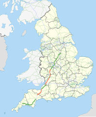
| Description | Map showing the route of the A38 in England. The green sections are parts designated as a primary route, the red sections are parts that are not primary. The blue section is the A38(M) motorway. Other motorways and primary routes are shown in a paler colours and the background map shows English ceremonial counties. |
| Date | |
| Source |
National Geospatial-Intelligence Agency
|
| Author | Nilfanion, using Ordnance Survey data |
| Permission (Reusing this file) |
This file is licensed under the Creative Commons Attribution-Share Alike 3.0 Unported license. Attribution: Contains Ordnance Survey data © Crown copyright and database right
|
File history
Click on a date/time to view the file as it appeared at that time.
| Date/Time | Thumbnail | Dimensions | User | Comment | |
|---|---|---|---|---|---|
| current | 16:40, 23 November 2010 | | 1,108 × 1,345 (2.22 MB) | Nilfanion | thicker county lines , fix coast |
| 23:26, 19 November 2010 |  | 1,108 × 1,345 (2.21 MB) | Nilfanion | thicken line | |
| 23:15, 19 November 2010 |  | 1,108 × 1,345 (2.21 MB) | Nilfanion | {{Information |Description=Map showing the route of the A38 in England. The green sections are parts designated as a primary route, the red sections are parts that are not primary. The blue section is the w:A38(M) motorway. Other motor |
File usage
The following pages on the English Wikipedia use this file (pages on other projects are not listed):
Global file usage
The following other wikis use this file:
- Usage on de.wikipedia.org
- Usage on nl.wikipedia.org
- Usage on pl.wikipedia.org
- Usage on www.wikidata.org