
File:2010 Dimi Evrytanias numbered.svg

Size of this PNG preview of this SVG file: 472 × 599 pixels. Other resolutions: 189 × 240 pixels | 378 × 480 pixels | 605 × 768 pixels | 807 × 1,024 pixels | 1,614 × 2,048 pixels | 737 × 935 pixels.
Original file (SVG file, nominally 737 × 935 pixels, file size: 44 KB)
| This is a file from the Wikimedia Commons. Information from its description page there is shown below. Commons is a freely licensed media file repository. You can help. |
| Description |
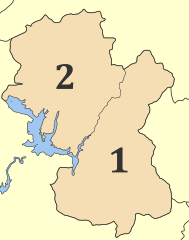
English: Municipalities (dimi) of Evrytania prefecture, Greece 2010:
1. Dimos Karpenisiou 2. Dimos Agrafas Deutsch: Gemeinden (dimi) der griechischen Präfektur Evrytania 2010: 1. Dimos Karpenisiou 2. Dimos Agrafas |
| Date | |
| Source | |
| Author |
| This is a retouched picture, which means that it has been digitally altered from its original version. Modifications: 2010 changes …. The original can be viewed here: Evrytania prefecture, Greece - political map - muncipality level - numbered.svg:
|
I, the copyright holder of this work, hereby publish it under the following licenses:
This file is licensed under the Creative Commons Attribution 3.0 Unported license.
- You are free:
- to share – to copy, distribute and transmit the work
- to remix – to adapt the work
- Under the following conditions:
- attribution – You must give appropriate credit, provide a link to the license, and indicate if changes were made. You may do so in any reasonable manner, but not in any way that suggests the licensor endorses you or your use.

|
Permission is granted to copy, distribute and/or modify this document under the terms of the GNU Free Documentation License, Version 1.2 or any later version published by the Free Software Foundation; with no Invariant Sections, no Front-Cover Texts, and no Back-Cover Texts. A copy of the license is included in the section entitled GNU Free Documentation License. |
You may select the license of your choice.
Original upload log
This image is a derivative work of the following images:
- File:Evrytania_prefecture,_Greece_-_political_map_-_muncipality_level_-_numbered.svg licensed with Cc-by-3.0, GFDL
- 2007-09-07T04:38:56Z Christaras A 744x943 (99886 Bytes) {{Information |Description=English: [[w:en:Evrytania]] prefecture, [[w:en:Greece]]. Low-detail political map on dimos level. With Numbers.Deutsch: Präfektur [[w:de:Evrytania]], [[w:de:Griechenland]]. Niedrig-detaillierte pol
- 2007-09-07T04:35:53Z Christaras A 744x943 (99847 Bytes) == Summary == {{Information |Description=English: [[w:en:Evrytania]] prefecture, [[w:en:Greece]]. Low-detail political map on dimos level. With Numbers.Deutsch: Präfektur [[w:de:Evrytania]], [[w:de:Griechenland]]. Niedrig-de
- 2007-09-07T04:30:04Z Christaras A 740x925 (99391 Bytes) {{Information |Description=English: [[w:en:Evrytania]] prefecture, [[w:en:Greece]]. Low-detail political map on dimos level. With Numbers.Deutsch: Präfektur [[w:de:Evrytania]], [[w:de:Griechenland]]. Niedrig-detaillierte pol
File history
Click on a date/time to view the file as it appeared at that time.
| Date/Time | Thumbnail | Dimensions | User | Comment | |
|---|---|---|---|---|---|
| current | 22:20, 10 July 2010 | | 737 × 935 (44 KB) | Pitichinaccio | numbers corr. |
| 22:11, 9 July 2010 |  | 737 × 935 (43 KB) | Pitichinaccio | {{Information |Description={{en|1=Municipalities ''(dimi)'' of Evrytania prefecture, Greece 2010:<br /> 1. Dimos Karpenisiou<br />2. Dimos Agrafas}} {{de|1=Gemeinden ''(dimi)'' der griechischen Präfektur Evrytania 2010:<br /> 1. Dimos Karpenisiou<br />2. |
File usage
The following pages on the English Wikipedia use this file (pages on other projects are not listed):
Global file usage
The following other wikis use this file:
- Usage on ar.wikipedia.org
- Usage on ceb.wikipedia.org
- Usage on cs.wikipedia.org
- Usage on da.wikipedia.org
- Usage on de.wikipedia.org
- Usage on de.wikivoyage.org
- Usage on eo.wikipedia.org
- Usage on es.wikipedia.org
- Usage on et.wikipedia.org
- Usage on eu.wikipedia.org
- Usage on fi.wikipedia.org
- Usage on he.wikipedia.org
- Usage on hy.wikipedia.org
- Usage on it.wikipedia.org
- Usage on ja.wikipedia.org
- Usage on ka.wikipedia.org
- Usage on ko.wikipedia.org
- Usage on no.wikipedia.org
- Usage on pl.wikipedia.org
- Usage on ro.wikipedia.org
- Usage on ru.wikipedia.org
- Usage on sr.wikipedia.org
- Usage on tr.wikipedia.org
- Usage on uk.wikipedia.org
- Usage on ur.wikipedia.org
- Usage on www.wikidata.org
- Usage on zh.wikipedia.org