
File:1967 MBTA subway map.jpg

Size of this preview: 564 × 600 pixels. Other resolutions: 226 × 240 pixels | 451 × 480 pixels | 722 × 768 pixels | 963 × 1,024 pixels | 1,536 × 1,634 pixels.
Original file (1,536 × 1,634 pixels, file size: 787 KB, MIME type: image/jpeg)
| This is a file from the Wikimedia Commons. Information from its description page there is shown below. Commons is a freely licensed media file repository. You can help. |
Summary
| Description |
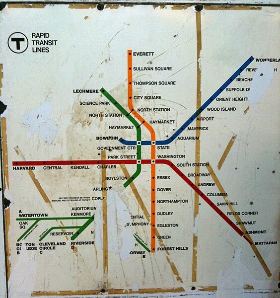
English: Old MBTA Rapid Transit system map, reflecting network from 1967 (line colors assigned) to 1969 ("A" Branch discontinued). |
| Date | |
| Source | This map was displayed at Orient Heights station until 2012; this photograph was taken by a Wikipedia user in 2010. |
| Author |
Map by Cambridge Seven Associates for the Massachusetts Bay Transportation Authority. Photograph taken by Angrtre at English Wikipedia. |
Licensing
This work is in the public domain in the United States because it was published in the United States between 1929 and 1977, inclusive, without a copyright notice. For further explanation, see Commons:Hirtle chart as well as a detailed definition of "publication" for public art. Note that it may still be copyrighted in jurisdictions that do not apply the rule of the shorter term for US works (depending on the date of the author's death), such as Canada (50 p.m.a.), Mainland China (50 p.m.a., not Hong Kong or Macao), Germany (70 p.m.a.), Mexico (100 p.m.a.), Switzerland (70 p.m.a.), and other countries with individual treaties.
|
 |
Original upload log
The original description page was here. All following user names refer to en.wikipedia.
- 2010-05-19 00:00 Angrtre 1536×1634× (663705 bytes) {{Information |Description = MBTA Rapid Transit system map, reflecting network from 1964-1969 |Source = I (~~~) created this work entirely by myself. |Date = ~~~~~ |Author = ~~~ |other_versions = }}
File history
Click on a date/time to view the file as it appeared at that time.
| Date/Time | Thumbnail | Dimensions | User | Comment | |
|---|---|---|---|---|---|
| current | 03:04, 15 May 2020 | | 1,536 × 1,634 (787 KB) | Dicklyon | Levels adjusted. |
| 04:10, 15 September 2011 |  | 1,536 × 1,634 (648 KB) | File Upload Bot (Magnus Manske) | {{BotMoveToCommons|en.wikipedia|year={{subst:CURRENTYEAR}}|month={{subst:CURRENTMONTHNAME}}|day={{subst:CURRENTDAY}}}} {{Information |Description={{en|MBTA Rapid Transit system map, reflecting network from 1967-1969. Photograph of map uncovered at Orient |
File usage
The following pages on the English Wikipedia use this file (pages on other projects are not listed):
Global file usage
The following other wikis use this file:
- Usage on de.wikipedia.org
- Usage on fr.wikipedia.org