
File:1910 South African general election map.svg

Size of this PNG preview of this SVG file: 800 × 466 pixels. Other resolutions: 320 × 186 pixels | 640 × 373 pixels | 1,024 × 596 pixels | 1,280 × 745 pixels | 2,560 × 1,491 pixels | 862 × 502 pixels.
Original file (SVG file, nominally 862 × 502 pixels, file size: 2.81 MB)
| This is a file from the Wikimedia Commons. Information from its description page there is shown below. Commons is a freely licensed media file repository. You can help. |
Summary
| Description |
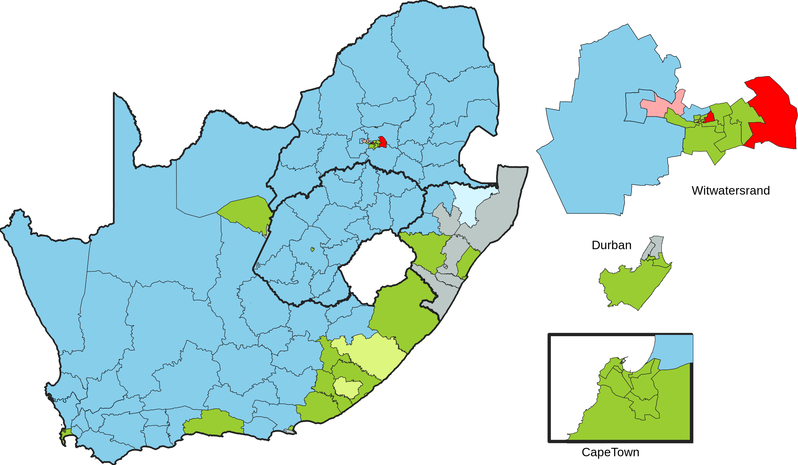
English: Map of the results of the 1910 South African general election, showing the party of the winning candidate by constituency.
Darker line shows the outline between the various provinces.
|
| Date | |
| Source | Own work. Constituency boundaries based on the 1910 'Report of the Delimitation Commission under the South Africa Act, 1909'. Constituency parties based on figures in 'Parlementere Verkiesings in Suid-Afrika 1910-1976' |
| Author | MrPenguin21 |
Licensing
I, the copyright holder of this work, hereby publish it under the following license:
This file is licensed under the Creative Commons Attribution-Share Alike 4.0 International license.
- You are free:
- to share – to copy, distribute and transmit the work
- to remix – to adapt the work
- Under the following conditions:
- attribution – You must give appropriate credit, provide a link to the license, and indicate if changes were made. You may do so in any reasonable manner, but not in any way that suggests the licensor endorses you or your use.
- share alike – If you remix, transform, or build upon the material, you must distribute your contributions under the same or compatible license as the original.
File history
Click on a date/time to view the file as it appeared at that time.
| Date/Time | Thumbnail | Dimensions | User | Comment | |
|---|---|---|---|---|---|
| current | 15:22, 24 August 2023 | | 862 × 502 (2.81 MB) | MrPenguin21 | Updated borders in Orange Free State (Edenburg) |
| 01:32, 25 February 2023 |  | 862 × 502 (2.78 MB) | MrPenguin21 | Updated borders in Western Cape (Malmesbury / South Peninsula / Ceres / Piquetberg) | |
| 22:33, 24 February 2023 |  | 862 × 502 (2.79 MB) | MrPenguin21 | Updated Port Elizabeth South-West (to Ind) and Beaconsfield (to Ind) | |
| 01:07, 19 February 2023 |  | 862 × 502 (2.79 MB) | MrPenguin21 | Thickened province outlines | |
| 00:54, 19 February 2023 |  | 862 × 502 (2.79 MB) | MrPenguin21 | Uploaded own work with UploadWizard |
File usage
The following pages on the English Wikipedia use this file (pages on other projects are not listed):